Why the idea of a Proto-South China Sea is untenable
See also notes on the geometry problem of the South China Sea
In part 1 of a discussion of the Proto-South China Sea some points were raised about the plate suture that should occur around the entire Plate of Dangerous Grounds (PODG) and the timing of stages in the history of the model for subduction of the Proto-South China Sea. These are summarised in brief below. When it comes to discussion of ages there is normally supporting data on how data was determined, often mixing magneto-stratirgaphic data and biostratigraphy, as well as K/Ar radiometric dating of igneous rocks. These specialised caveats are not covered below, but are covered with more details in some papers in press.
A third topic is added, which is the story from the deposition of the Kudat Formation in northern Borneo, which on its own is a strong argument against the existence of the Proto-South China Sea
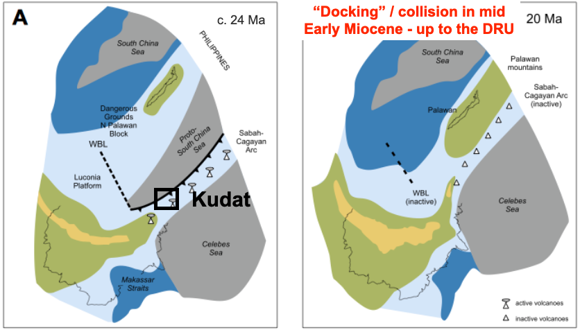
1. Where is the PODG suture?
Any migrating plate must have an edge. One edge next to a spreading center, then some wrench or transform faults, and a somewhere roughly opposite spreading, an edge that is a subduction zone where oceanic rust is consumed. An accretionary wedge builds up over the subduction margin, and upon collision there is a continuous suture where one plate made contact with the opposing plate. An orogeny around this suture is expected.
This is what is missing from northern Palawan. On neither side of north Palawan can any such suture, accretionary wedge or orogeny be detected. Seismic around the region, including new data in the north Sulu Sea (Weller and Davies, 2019) can see none of these large scale features. On the western end of Panay Island, the far eastern edge of north Palawan continental crust is juxtaposed with the northern extension of the Cagayan Arc, and there is even one record of arc intrusion through these Jurassic beds; impossibly on the wrong side of the suture.
There cannot be a gap in the margin of something proposed to have been a migrating plate.
2. Timing
Some aspects of timing are detailed below in the discussion of the Kudat Formation. Briefly, the only positive reason Silver and Rangin (1991) proposed a model of subduction from the north and a Proto-South China Sea was because of the similar ages of the sea-floor spreading in the axis of South China Sea and the approximate ages of the Cagayan volcanic arc. (In fairness Holloway, 1982, had speculated on plate reconstructions with parts of Palawan separated from Borneo by an oceanic plate, but these were very early speculations, proposed not long after plate tectonics had become mainstream thinking, and with some very usual characters that are now discounted).
The match in ages of plate drift and Cagayan volcanic activity is now known to be poorer that assumed by Silver and Rangin. There is the entire Oligocene where there was drift but no arc, and the arc continued long after all drift had finished. However the Cagayan Arc has a history that overlaps with the Sulu arc and the extension of north Sabah (mélanges) and new oceanic crust under the Sulu Sea. Both Rangin (1989) and Hall (2013) reconstruct this history to associate the Cagayan Arc with the formation of intra arc spreading and the migration of the younger Sulu Arc to the SE, towards the driving force.
3. The Kudat Fm. arguement
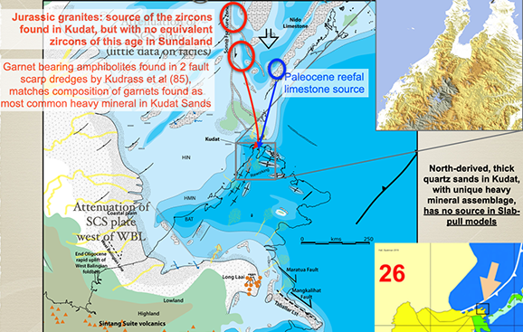
The Kudat Fm. is an exceptionally sandy, quartzose formation in the northwest of Sabah, with palaeocurrents indicating it was derived from the north (at least two sets of workers). Not only is is far sandier than the Crocker Formation to the south – into which it sees to grade – but the Kudat mineralogy is distinct from the Crocker and any other formation in Borneo. The heavy minerals contain far more garnet that any other sediment, and an acme of late Jurassic zircons which are absent from the other Borneo beds. There are sources of garnets and late Jurassic zircons found by German and Chinese dredge samples in the area west of the Reed Bank – which of course are north of the Kudat Peninsula. The key aspect is the age.
For years people just repeated the 1956 and 1961 mapping conclusions that the Kudat Formation was Early Miocene with a major terminal unconformity in “mid Miocene” times. Unfortunately this is not true. The observed fossils indicate the Kudat to be Letter Stage Te2-4, with the post unconformity transgression over the area being Letter Stage Te5. This unconformity was long recognised as a major regional event over all of north Borneo. Ever since Reinhard and Wenk (1951) all workers had recognise the deformation of the Te2-4 age beds overlain by much less deformed Te5 beds. This deformation was described as “This maximum movement took place between Te4 and Te5. This is the most important Tertiary orogeny of North Borneo” (Reinhard and Wenk, 1951 p.21 their emphasis)
In 1964 we only had a poor correlation of SE Asia Letter Stages with the European Epochs. This developed considerably with the development of planktonic biostratigraphy in the 1970’s and 80’s and the integration of the Letter Stages to this scheme in the 1990’s and early 2000’s (see van Gorsel et al. 2014).
So general geologists repeated the “Kudat Formation is Early Miocene” mantra right up to 2013 (Hattum et al.), which roughly fitted the expected tectonic history. It was expected that the PODG migrated southeast as the South China Sea underwent drift in the Early Miocene, then “docked” (collided) in later Early Miocene time, terminating the sea-floor spreading in the northwest. Even with this model there are timing issues as some workers date the end of drift as old as 20 Ma in early Early Miocene (Barckhausen et al. 2004, 2014), although some claim drift continued until about 17 or 16 Ma (Briais et al., 1993). The end of the drift is far too old for the Deep Regional Unconformity, which was assumed to be the end-docking unconformity (12-13 Ma vs 16/17 or 20 Ma). Also the syn-depositional deformation of the Kudat Formation would have to have been mid or late Early Miocene, roughly 20 to 15 Ma, when the Letter Stage data clearly indicates this was about 26 to 25 Ma, in the Late Oligocene.
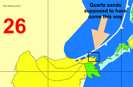
The Proto-South China Sea model requires that in the Late Oligocene the Proto-South China Sea oceanic crust must have have been west, northwest, and north of the Kudat Peninsula, and northeast of Kudat there was Mesozoic oceanic crust under the Sulu Sea. This is an impossible source for richly quartzose sand, lacking ophiolitic lithic clasts, and with the high grade metamorphic garnets and Jurassic zircons. The only solution is that the PODG was aready next to Kudat – as it is today – and there was no Proto-South China Sea.
If there was no Proto-South China Sea there could have been no subduction, and no slab-pull driver for the plate motions postulated for Sundaland, including the much debated counterclockwise rotation of Borneo (Hall and Morley, 2004; Hutchison 2005, p.13 and elsewhere). If this slab-pull model does not work to drive tectonic movement in Sundaland, what does? The Extrusion model of Tapponnier is flawed (see Replumaz and Tapponnier, 2003 for an updated account of the original 1982 model), not least as it is exclusively extensional; the pulling away of one block from another leaving a gap. The widesprea compressive event of “the most important Tertiary orogeny of North Borneo” does not fit this simple model.
Referances
Barckhausen, U., Roeser, H.A., 2004. Seafloor Spreading Anomalies in the South China Sea Revisited. In P. Clift, P. Wang, W. Kuhnt, & D. Hayes (Eds.), Continent-ocean interactions within East Asian marginal seas, 121-125. Washington: American Geophysical Union.
Barckhausen, U., Engels, M., Franke, D., Ladage, S., Pubellier, M., 2014. Evolution of the South China Sea: Revised ages for breakup and seafloor spreading. Marine and Petroleum Geology 58, 599-611
Briais, A., Patriat, P., Tapponnier, P., 1993. Updated interpretation of magnetic anomalies and seafloor spreading stages in the South China Sea: implications for the Tertiary tectonics of southeast Asia. Journal of Geophysical Research 98 B4, 6299-6328
van Gorsel, J.T., Lunt, P., Morley, R.J., 2014. Introduction to Cenozoic biostratigraphy of Indonesia- SE Asia. Berita Sedimentologi 29, 4-40
Hall, R., Morley, C.K., 2004. Sundaland Basins. In P. Clift, P. Wang, W. Kuhnt, & D. Hayes (Eds.), Continent-Ocean Interactions within the East Asian Marginal Seas, 55-85.
Hattum, V., M.W.A., Hall, R., Pickard, A.L., Nichols, G., 2013. Provenance and geochronology of Cenozoic sandstones of northern Borneo. Journal of Asian Earth Sciences 76, 266-282
Hutchison, C.S., 2005. Geology of North-West Borneo: Sarawak, Brunei, and Sabah. Elsevier Science.
Reinhard, M., Wenk, E., 1951. Geology of the colony of North Borneo. Geological Survey Department of the British Territories in Borneo (Bulletin) 1, 160pp
Replumaz, A., Tapponnier, P., 2003. Reconstruction of the deformed collision zone Between India and Asia by backward motion of lithospheric blocks. Journal of Geophysical Research 108(B2)
Silver, E.A., Rangin, C., 1991. Leg 124 Tectonic synthesis. In Proceedings of the Ocean Drilling Program, Scientific Results, 3-9.
Stephens, E.A., 1956. The geology and mineral resources of part of the Kota Belud and Kudat area North Borneo. Geological Survey Department, British Territories in Borneo. Memoir 5
Tapponnier, P., Peltzer, G., LeDain, A.Y., Armijo, R., 1982. Propogation extrusion tectonics in Asia: new insights from simple experiemtns with plasticine. Geology 10, 611-616
Weller, A., Davies, K., 2019. The underexplored East Palawan Basin. GEOExPro 16(2), 52-54
Wilson, R.A.M., 1961. The geology and mineral resources of the Banggai Island and Sugut River area, North Borneo. Geological Survey Department, British Territories in Borneo.
[…] separate, second entry (part 2) discusses new data indicating that there never was an oceanic plate called the Proto-South China […]
[…] questioning established models for the Proto-South China Sea slab pull tectonic model (Post 1, Post 2, Post […]