Follow up from AAPG workshop, Oct 2021. See also this link, and this one.
Minor notes on Cycle I are in this post introducing the Cycles of Sarawak
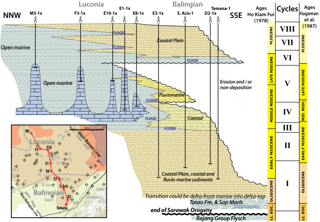
The base of Cycle I was never defined but it is usually assumed to be the Rajang Unconformity near the top of the Middle Eocene (near top Letter Stage Ta). Another widely believed assumption is that the thick fluvio-deltaic siliciclastics see in many offshore wells continue with depth and probably have even more proximal delta-plain facies below. The assumption is a rift-sag basin mind-set, which I questioned in my AAPG talk.
The last decent fieldwork in the one area where this could be resolved was in 1960, by Brian Wolfenden (area circled on map below), who noted the Eocene Arip Volcanics were air-fall, welded tuffs, close to the Rajang Unconformity, so the assumption of a long-lasting shallow or non-marine environment looked OK. The tuffs were well described and illustrated in thin section. In 1960 micropalaeontology was a developing science and microfaunas were observed in the multiple sedimentary formations, but the schemes to translate these faunas to environments of deposition were not yet published. However, the listed microfaunas through the later Eocene and Early Oligocene suggested a bathyal marine setting.
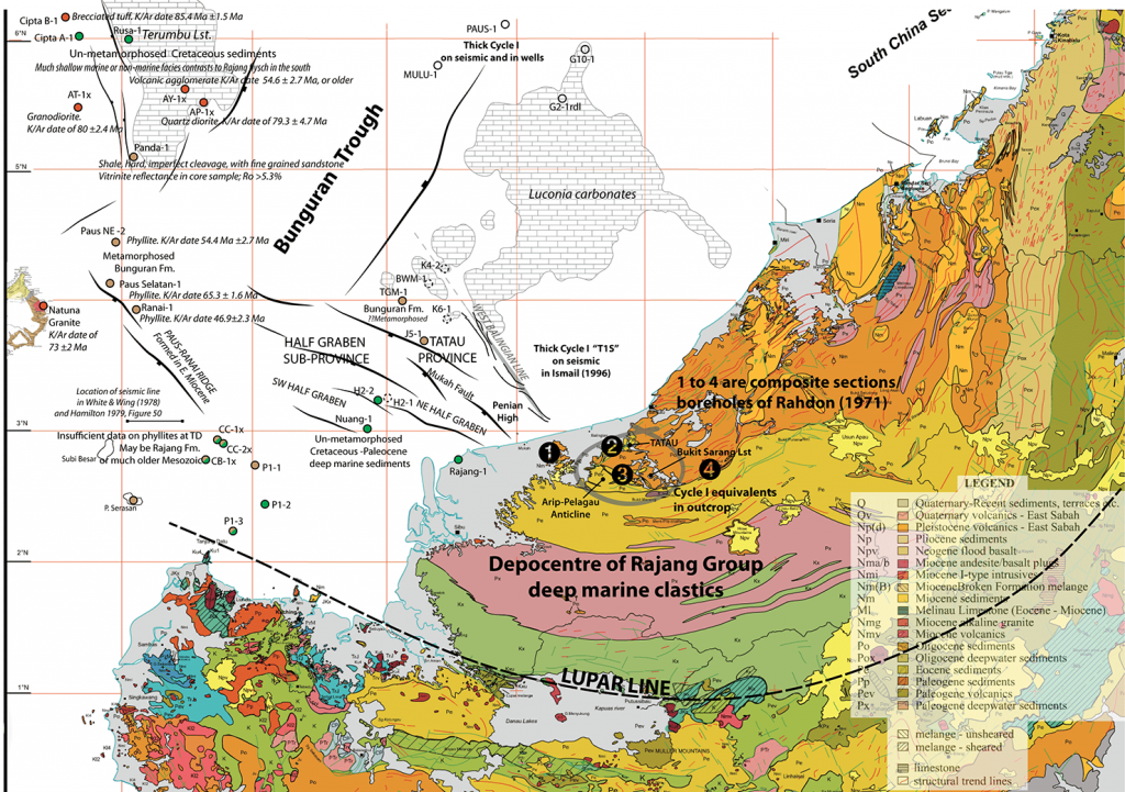
Cores drilled onshore near the Arip-Pelagau Anticline in 1935 and analysed by Schumacher in 1940 (see Liechti, 1960) found a marly claystone called the Penian Formation or marls. These were re-examined in 1959 and could be dated as what we now call the Early Oligocene, based on planktonic foraminifera and they were summarised as “marine microfauna indicate deposition in a deeper sea than that characteristic for the other formations of the Balingian area”, so it was not just Wolfenden’s field-work seeing these deep marine facies. In 1957 the Bukit Sarang Limestone was discovered nearby and in 1960 described as a reefal carbonate of Letter Stage Tc age. I have examined a large number of thin sections from this limestone and can confirm this early Early Oligocene age. The carbonate was sediment starved. Such a shallow marine facies is not likely to have co-existed with a surrounding fluvio-deltaic coastal plain.
The two wells offshore that drilled Cycle I over basement had deltaic siliciclastics over a structural high, and the lower Palaeogene is missing.
So we have a conundrum. There was clearly a lot more going on during the 15 million years lumped into Cycle I. Regionally we see major plate tectonic events and unconformities at the Eocene-Oligocene boundary (34 Ma) and also in mid Oligocene times (about 28 Ma). We know from seismic in Nam Con Son and West Natuna there are older rifting phases that suddenly accelerated and expanded, but these are very poorly dated. We are not sure of the role of the West Balingian Line fault (NW to SE on map above), but it is an old feature that strongly influenced deposition of the Upper Cycle I.
So anyone gathering assumptions on Cycle I to apply to seismic in deep water Sarawak is taking very large risks. Not entirely their fault, as noted above much of the unusual data on older Cycle I is in the “small-print” details of field and other reports – the sort that no one reads nowadays. For comparison, when Sampaguita and the other Reed Bank wells were drilled in west South China Sea (1970s) the Palaeogene sections that were found were entirely unexpected, with variable environments of deposition, and lacking any rift-sag tectono-stratigraphic components.
I think it is absolutely paramount to go back to the wider Arip-Pelagau Anticline outcrops and sort out what data is available on Cycle I. I have done much research and can confirm this is a real gap in data, even in oil company and university files. What is more, this work is too important to give to a student. Fieldwork is not just heading off with a GPS and hammer. Professional field geologists are nearly gone, and those who can sample properly for different disciplines are rare within an already small community. Bukit Sarang is probably out of reach, surrounded by swamp, but the archived thin sections are many and excellent. A small effort by students in this region a few years ago was a scientific disaster for stratigraphy. That is, based on just a few samples it published data completely at odds with the previous solid work by the Malaysian Geological Survey (a major, well-funded and well-run survey lasting years), and was both mis-direction and a lost opportunity. The geological survey data, as noted above, is not high profile. The new mis-direction is in widely available PDF format. The next study has to get it right and sort out this confusion.
References
Liechti, P., 1960. The geology of Sarawak, Brunei and the western part of North Borneo (Bulletin 3). Kuching Sarawak: Geological Survey Department British Territories in Borneo.
Wolfenden, E.B., 1960. The geology and mineral resources of the lower Rajang Valley and adjoining areas, Sarawak (Mem. 11). Geological Survey Dept. British Territories in Borneo.
Be First to Comment