Journal of Asian Earth Sciences, accepted
This paper is one of a set on eastern Java and the Makassar Straits:
- Lunt, P., 2019. The origin of the East Java Sea basins deduced from sequence stratigraphy. Marine and Petroleum Geology 105, 17-31
- Luan, X., Lunt, P., 2021. Eocene to Miocene stratigraphic controls in the far East Java Sea: Implications for stratigraphic studies. Marine Geology 436, 106479
- Luan, X., Lunt, P., 2021. Latest Eocene and Oligocene tectonic controls on carbonate deposition in eastern Java and the south Makassar Straits, Indonesia. Journal of Asian Earth Sciences,
- Luan, X., Lunt, P., 2021. Occurrence in space and time of the Globigerina-sands of eastern Java; their stratigraphy, and controls on reservoir quality. Marine and Petroleum Geology

This is ambitious and long paper covering many wells in considerable detail, in which many observations of age and facies had to be justified. Petrographic reports on carbonates included larger foraminifera images and fauna that had been missed by biostratigraphers, and there is a lot of commentary of the machine precision of mass-spectrometry of Sr isotopes, and also the contamination of these ratios, all of which requires biostratigraphy to verify, and often reject.
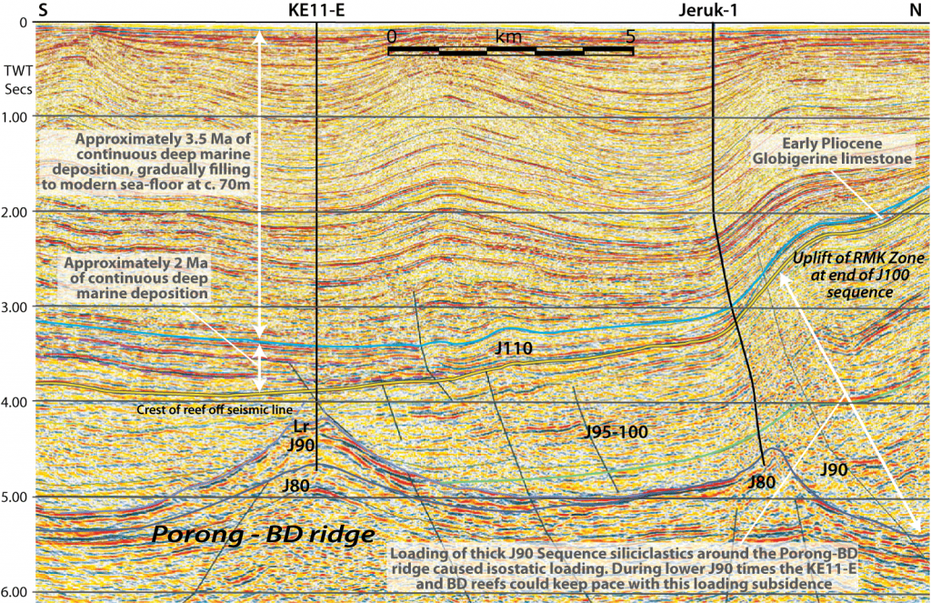
Previous work (e.g. Kusumastuti et al., 2002) had tried to fit reef growth into a passive setting and while, wisely, not claiming to recognise the signature of Haq’s sea-level curve, had made some invalid correlations, and the stratigraphic synthesis was not checked by non-seismic data. Multiple papers were well-written examples of confirmation bias. However, by including data from siliciclastic sections and using geohistory methods it appears more likely that the Early Miocene pinnacle reefs of NE Java and the Madura Straits first grew along-side the more widespread basal Early Miocene (Letter Stage Te5) Kujung Unit I reefs. Then, in mid Early Miocene times, an acceleration of isostatic loading from Tawun Claystones drew these reefs out to become isolated pinnacles, but only in the area proximal to the Sundaland Shelf, and off the Kujung shelf edge. The influx of siliciclastics at the same time as reef deposition was not ideal for carbonate deposition, and it is thought this eutropic pollution was an environmental pressure leading to backstepping, rather than sea-level change. This is supported by the observation that all these reefs became extinct at c. 16 Ma (again having to validate a wide range of age data). This coincides with the N8 Inversion of central Borneo which accelerated the progradition of siliciclastics, and this is thought to have been the final pollution event terminating reef growth. Loading and subsidence continued to bury these reefs several km below modern sea-level.
The paper covers a range of observations on the Early Miocene of SE Sundaland, in a dynamic geological setting. This was a new palaeogeography after the Oligo-Miocene boundary unconformity discussed in previous papers (see links). It continues to build a validated tectono-stratigraphic framework using natural stratigraphic units as well as a quantitative assessment of sedimentation, accommodation space and both tectonic and isostatic subsidence. Unless you know the area it may seem a bit dense and detailed, but we are trying to publish several data-rich reports such as this as we move towards a new paradigm on the sedimentary geology and tectono-stratigraphy of Sundaland. There is much to do clarifying the old, inaccurate data (the date and style of unconformities; the correlation of tectonic events; and the accelerations in tectonic subsidence – where others have assumed deceleration from rift to sag). Eventually we will bring it all together, but long-winded papers such as this, with 19 data-packed figures are the basis for such an evidence-based approach. For too long we have had ideas based on models, and data has taken a back seat. Models never predicted the incredibly fast subsidence of the Makassar Straits, fading in intensity laterally but linked to the widespread Kujung/ Batu Raja Limestone transgressions over the flanks of Sundaland. Models could be “bent” to claim sea-level had affected the pinnacle reefs studied in this paper, but these do not correlate, and the effects of isostatic loading were simply not measured.
Models cannot undo this change to evidence-based work, only more analysis and quantitative integrations such as geohistory can challenge the new empirical framework. Please feel free to counter what we claim in this paper, we will have at least succeeded in forcing a change back to objective, empirical methods!
If stratigraphy wants to take its place as the integrating heart of sedimentary geology it has to look beyond offering simple chronostratigraphic tie lines. Seismic can do most of that correlation work. Stratigraphy must describe sedimentary systems, and in the dynamic geology of South East Asia the character of the times of change. Natural sedimentary sequences must be recognised and used, and quantitative summaries made of subsidence, accommodation space histories (palaeobathymetry) and uplift. We currently see bits of this work in some studies, but we need a robust and predictive framework. Migas, and in Malaysia Petronas, are releasing data and asking for new ideas. However, industry seems to have lost the skills to formulate both the new questions and certainly to find any new answers.
The paper has been accepted. Contact me if you want a pre-print. When published I will replace this sentence with a link.
References
Kusumastuti, A., P. van Rensbergen, and J. K. Warren, 2002, Seismic sequence analysis and reservoir potential of drowned Miocene carbonate platforms in the Madura Strait, East Java, Indonesia: AAPG Bulletin, v. 86, no. 2, p. 213-232.
Some background on Kusumastuti et al. 2002
This is not a bad seismic interpretation paper for its time, but after reading it one is left wondering “what is it about?” It suggests 4 relative sea-level stages during the Early Miocene but hesitates, in the fashion of good scientific diffidence, to link these to eustasy. Which is good, as the 4 events are mis-correlated and there are “some” stages seen in gradually back-stepping pinnacles that can’t be correlated between reefs. These reefs are atypically high relief for the region, but this anomaly was not noticed. I think this is because the Madura Straits and onshore NE Java was the main catchment area for mid and Late Early Miocene siliciclastics. The area was loaded by the weight of these sediments and this isostatic forced subsidence so only high relief features survived. I also think that a final acceleration of siliciclastic influx was responsible for the termination of nearly all the reefs at the same time.
The Geological Evolution in the introduction of the Kusumastuti et al. paper is a particularly galling summary of half-truths and omissions, as if geology and stratigraphy did not matter. The Old Andesites had an acme of activity, and them abruptly terminated at c. 20 Ma (radiometric dates) and were capped by new carbonates over their eroded stubs (stratigraphic observations). The speculation that “the terminal drowning [of the Madura Straits pinnacle reefs] may reflect proximity to the Old Andesite volcanic arc in the south, which periodically shed ash and other debris that made the East Java basin inimical to carbonate growth” is just one example of mis-statement and paper-padding blather that was known to be wrong a decade or more before this 2002 paper. Blur things in time, blur facies, and blur mechanisms and nearly any story appears plausible. This is what Karl Popper warned us about. It is what stops geology from being a science.
Be First to Comment