A term I use frequently in this blog is that if a “non-Waltherian contact”. This is a deliberately broad description of a horizon in a congeneric stratigraphic succession where Walther’s Law break’s down. The sediments have to be congeneric; that is, away from the focus of the unconformity the facies contrast will fade into a correlative conformity.
Unconformities have a history of jargon and disagreement. Is a paraconconformity the same as a disconformity or non-conformity? The trouble with current terminology for unconformities is that the same surface can be given different names at different locations. Once again in stratigraphy, the classification of features becomes a distracting quagmire of terminology. A non-Waltherian contact [NWC] only assumes the worker has used a broader view of facies other than just simple lithofacies (especially considering the environment of deposition from fossils), and can recognise that the facies in a succession up to the NWC all form a contiguous body of laterally connected facies, and the NWC represents a step where the whole sedimentary system has suddenly shifted to a new setting. Up-section from the NWC the facies relationships are stable again. Therefore a non-Waltherian contact is where Walther’s Law, at the scale of observation, abruptly breaks down, even if no angularity is seen. It is a way of looking at unconformities based on sedimentary change, rather than the geometry of the unconformity in section view.
In standard eustatic sequence stratigraphy the selection of the sea-level fall (maximum regressive surface) as the sequence boundary (in preference to maximum floods, as suggested by Galloway and others) is the NWC in such curvilinear approaching sinusoidal sequences.
I will show many examples of these NWC events in posts on this site. Identifying and describing them is key to understanding the tectono-stratigraphy of SE Asia. I have published several examples already. One such instance is based on the work of field geologists and well analyses over about fifty thousand square kilometers of north Sumatra and west Thailand, described in Lunt (2019). Here is another:
Below is a seismic-based cross-section from eastern Java.
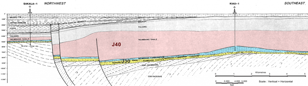
The Kiau-1 well in the southeast (right) drilled a low relief reef and has good quality analyses:

The reef was obviously deposited close to sea level (inner neritic). The workers interpreted a rapid transgression to a deep outer neritic to upper bathyal setting for the deposition of the claystones. The slope drawn in the environmental column on the right of the figure, covering about a hundred feet of section, is probably a guess, as the actual data shows all limestone samples to be shallow deposits, and all claystone samples to be deep marine facies (see below).

Ah! But this was a reef, and even the modest relief of this bioherm means that after subsidence there was a hiatus in sedimentation over the crest before the siliciclastic sediments onlapped the local high. In that thin missing section there could have been a transgressive suite of sediments deposited away from the reef. Obviously there was a transgression, and if there was sedimentation such a record would exist, but it would be very condensed. The key property to a NWC is a step-like nature: in this example several hundred feet of continuous inner neritic reef, then between two adjacent cuttings sample an abrupt change to many hundreds of feet of bathyal clays.
A reality-check is to look at the Sakala-1 well in the northwest. Here there was no relief to the thin, carbonate platform deposit.

At Sakala-1 there was a basal, paralic, coastal facies of siliciclastics containing the estuarine fossil Miliammina, passing up into inner neritic carbonate (a typical waltherian succession during a steady transgression). Even at this site the clay facies above the limestone is fully bathyal. Note that there is no discernable age gap. The limestone contains Letter stage Tb (Late Eocene) larger foraminifera and the clays above contain the Zone P15 marker Globigerinatheca semiinvoluta; that is, the often thick reefal limestone is early Late Eocene and the first deep marine clays are no younger than mid Late Eocene. The entire Late Eocene is only 3 million years long and 2 million years of that is above the G. semiinvoluta extinction datum!
Secondly, note how limestone beds are marked in the Sakala-1 lithology column, between 4700-4800′ and 5000-5100′. This is a case of dumbing-down to basic lithofacies, based on rock colour or grain size only. The main limestone at the base, drawn with the same symbol, is rich in shallow marine bioclasts. The thin carbonate beds above, within the deep marine clays, are a very different limestone facies. They are micrite-rich and contain planktonic foraminifera. Sometimes they can contain transported larger foraminifera, but apparently not in this well. They are a very different facies to the lower reefal limestone. We need a better use of symbols or colours to emphasis this important contrast.
This is a good example of just two of many wells over the whole eastern Java and south Makassar Straits area showing how the “bottom-dropped out” of at least 200,000 sq. km., at roughly 36 Ma (based on the extinction datum of G. semiinvoluta just above it). The cross section above shows how faulting was involved, and that the Kiau area developed into a new depocentre, and accumulated much thicker Late Eocene “Ngimbang Shale” (a horrible term, please don’t use it; try J40 Sequence instead) . The top of J40 is the Eocene-Oligocene boundary event, so the mid to late Late Eocene J40 claystone rich sequence was deposited at a very high rate of sedimentation. So in mid Late Eocene times, associated with a rapid subsidence, there must have been the appearance of a new siliciclastic sediment source.
The magnitude of this subsidence (relative sea-level rise) depends on location, but in both wells summarised here, and most others across the 200,000 sq. km. region, it was at least 200 metres, probably occurring in less than half a million years (this latter number needs defense from other wells not described here, but the entire early Late Eocene period described is only about 1 million years long, and this included the time needed to deposit thick limestones). This is an order of magnitude greater than any proposed eustatic event in the Cenozoic (see the mid-Eocene to Recent eustatic summary linked here). The same event is described in the Makassar Straits in Lunt and van Gorsel (2013) where up to 2 km of abrupt subsidence is measured at this time in the Pangkat Graben.
There is much more to investigate. Where was this new sedimentary source? Did it appear due to a known uplift event? These are the linking questions that comes out of this approach. They are considerations for later posts. Here I just wanted to use a clear example of a sedimentary system rapidly changing its architecture resulting in a non-Waltherian contact.
[…] which included multiple subsidence unconformities. These are seen in well sections as multiple non-Waltherian contacts, where very deep facies abruptly overly very shallow marine or non-marine […]
[…] geohistory for Bukoh-1 shows the abrupt nature of the non-Waltherian contact very clearly as there was negligible overburden deposited after this event, so almost no subsidence […]
[…] is not what the well data sees, with classic non-Waltherian contacts; thick delta-plain deposits laid down near sea-level suddenly overlain by thick bathyal clays with […]
[…] followed by long periods of very much deeper facies. These abrupt shift in facies I have termed non-Waltherian contacts, as most classifications of unconformities are biassed to reflect bedding angles, not facies […]
[…] Primary correlation datums in SE Asian stratigraphy – The Orbulina datum on Non-Waltherian Contacts […]
[…] A new role for stratigraphy, especially biostratigraphy – The Orbulina datum on Non-Waltherian Contacts […]