Where did the idea of the Proto-South China Sea come from?
A separate, second entry (part 2) discusses new data indicating that there never was an oceanic plate called the Proto-South China Sea, which appears in almost every plate tectonic summary of the North Borneo to South China Sea over the past two decades. This leaves the question, where did the concept of subduction of an ancient oceanic plate under NW Sabah come from?
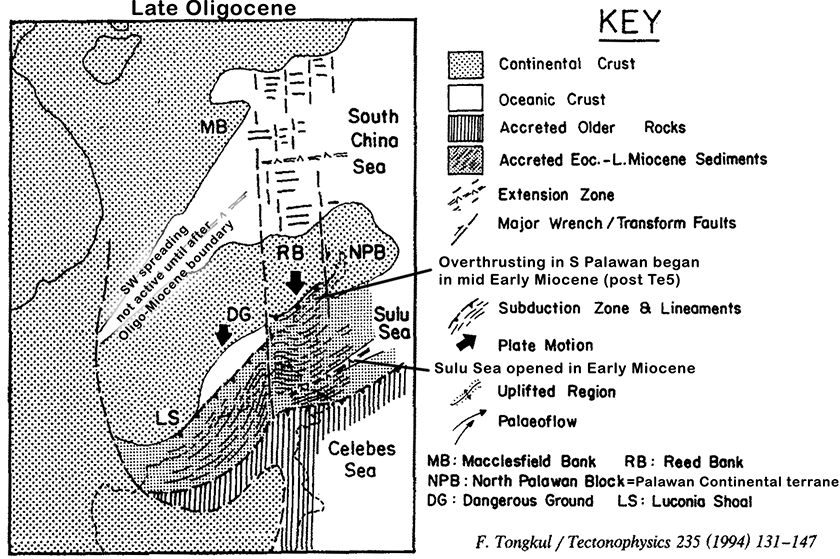
Some familiarity with location names is required. Hall and Breitfeld (2017) stressed that the proposed Proto-South China Sea was only the area north of the West Baram Line, and its proposed subduction was Oligo-Miocene and not the older Cenozoic or late Mesozoic subduction under a wider western Borneo area that gave rise to the Sarawak Orogeny in southwest Borneo, which terminated near the end of the Middle Eocene. In this text I use the term Plate of Dangerous Grounds (PODG) for the attenuated continental crust under the entire Dangerous Grounds, south of the axis of the South China Sea spreading. The Cagayan Arc is a long extinct ridge of volcanic activity under the west-central Sulu Sea, a feature that has long lacked a simple explanation. Zamboanga is the peninsula in the Philippines that is the northwards continuation of the islands of the Sulu Arc, on the eastern margin of the Sulu Sea.
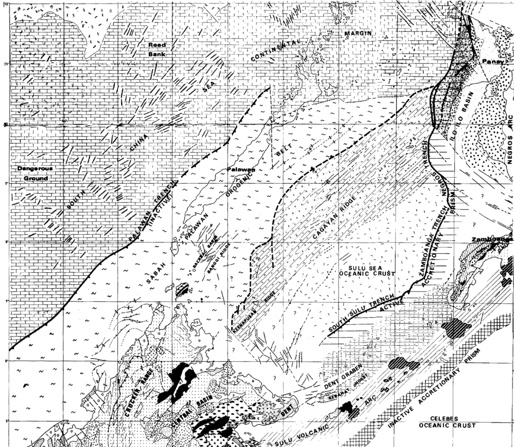
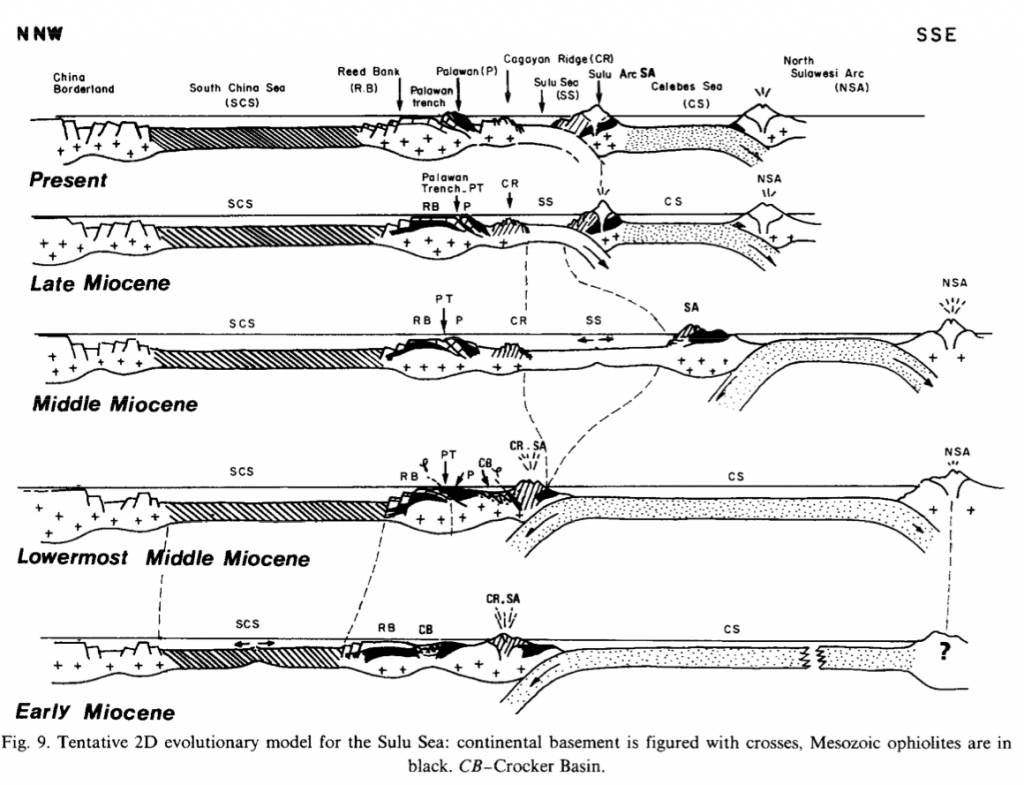
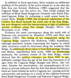
Going back thirty years, the model proposed by Rangin (1989) had the southern edge of the PODG (RB and CB on figure above) as passive, with Miocene and younger subduction from the SE, going under far eastern Sabah, as the cause of the Cagayan volcanic arc (Rangin 1989, his Figure 9, above). Rangin himself then led the change from this 1989 model in his subsequent papers that were associated with the first round of ODP work in the area (Leg 124, 1990). Silver and Rangin (1991, p.8; see extract below) proposed subduction was instead from the NW, passing below the western margin of Sabah and south Palawan, and they listed three reasons for this change in plate reconstruction. First was the lack of any subduction zone imaged on seismic around the Sulu Arc in the southeast. Secondly, the timing of the Cagayan Arc magmatism matched the date of “convergence along the north-west side of Palawan”. Thirdly, unpublished fieldwork on Zamboanga (Rangin & Muller; but partly published in Muller 1991) at the northernmost end of the Sulu Ridge, showed the earliest arc volcanics there were “Zone NN5 in age, definitely younger than the age of the Sulu Sea [oceanic] basement or of ages from the Cagayan Ridge”. This suggested that the older Cagayan Arc in the northwest was the arc associated with assumed back-arc spreading of the eastern Sulu Sea (both Early Miocene), and not the Sulu Ridge arc that was too young to be associated even with the later Early Miocene extension. Therefore the polarity of Cagayan Arc being west of back-arc spreading pointed to a driving subduction cause further west
So that was the reason for the change to subduction from the NW, under western Sabah and Palawan; geological features in a temporal framework. That is; both the location and the timing of geological features was critical to propose the model. The trouble is both these issues have major problems.
Where is the subduction zone?
This is a major problem as no subduction zone is visible on seismic data anywhere. As Hutchison. (2005 p. 192) pointed out, scale is important as small, elongate reverse faults exist, but these do not constitute a subduction zone. Hutchison was discussing faults either side of the Sulu Arc, neither side of which seems to be large enough to be a subduction feature, and they are also extremely close to the arc the are held responsible for. The linear, calc-alkaline volcanic Sulu Arc either suggests a now invisible Middle Miocene to Pleistocene subduction zone, or there was a different cause for the linear volcanic chain.
This leaves the major overthrusting on the northwest of Sabah and south Palawan as a candidate subduction zone. However a subduction zone is part of a suture between two plates, and this thrust zone is not. The overthrusting stops abruptly off the west coast of central Palawan. Seismic clearly shows just extensional grabens off northwest Palawan. Consequently people have assumed the suture deviates as a wrench-type fault (Ulugan Bay Fault) to the east side of north Palawan. However seismic in this area (Durkee, 1993; Weller and Davies, 2019) shows no subduction and the margin in which a plate suture could occur (between continental crust of North Palawan and oceanic crust under the Sulu Sea) narrows and eventually contacts the extension of the Cagayan Arc on Panay Island. There is neither evidence or room for a subduction zone, which would include an accretionary wedge of some volume.
When were convergence and the Cagayan Arc active?
The references Silver and Rangin cite for their ages – Hamilton (1979), Holloway (1982) and Hinz & Schlüter (1985) – are not of a high resolution on the topic of age dating, the latter being the most detailed, but it dates the cessation of subduction under Palawan at the mid Middle Miocene DRU event, a view not shared here. The DRU was a pause in the early phase of the Sabah Orogeny; a compressive event that began in latest Early Miocene times, lasting until about mid Pliocene times; a period after all spreading in the South China Sea had finished.
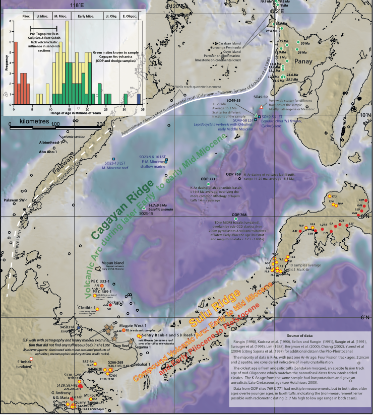
A compilation of data from the Cagayan Arc shows it was active through the Early and to mid Middle Miocene (see below). This data might be biassed as deeper, older volcanics are likely to be less well sampled. The extension of the Cagayan Arc as outcrops onto Panay islands have yielded the most radiometric ages, but none of these are older than Miocene.
The age of assumed convergence is not as clearly known. It was already known that much of the overthrusting and uplift of the western cordillera of Sabah and Palawan (Sabah Orogeny) was Middle through Early Pliocene. Dating the drift in the South China Sea in 1991 was based on magneto-stratigraphy by Taylor and Hayes (1983) and estimated to have been between 32 and 17 Ma (Early Oligocene to later Early Miocene). The fact that this roughly matched the ages from the Cagayan Arc implied convergence and subduction.
What was the timing of events on Zamboanga / Sulu Arc?
Silver and Rangin were approximately right to deduce that the Sulu Arc was younger than the age of the Sulu oceanic crust (with K/Ar ages of 20 to 15 Ma in ODP samples) and therefore not part of a model that assumes the Cagayan Arc was a volcanic chain caused by subduction, and the Sulu Sea was a back-arc spreading feature. They were wrong about the age of the Sulu volcanics not overlapping with Cagayan ages. Sea-floor dredges around the Cagayan Arc have basalts with ages of 14.7±0.6 Ma (SO23-15) or an average of 15.3 Ma (for 11 samples 11-20 Ma, from SO49-55) and numerous samples in the Antique Range of Panay from 25 to 13.1 Ma. Associated anc capping the volcanoes are limestones with Lower Tf larger foraminifera (older than between 12-13 Ma). The main volcaniclastic unit on Zamboanga [Pantalon and Mala volcanics] is overlain and sometimes interfingered with the Manicahan limestone which also contain lower Tf Miogypsina and Lepidocyclina (Nephrolepidina). These are equivalent to the Libong / Tungku Members (volcaniclastic) and overlying Tabin Limestone section in the Dent Peninsula at the south end of the Sulu Arc. For a short period in the early Middle Miocene both the Cagayan and Sulu Arcs were active, then the Cagayan Arc terminated but the Sulu Arc continued.
This suggests a related cause, but after the formation of the oceanic crust in the Sulu Sea the Cagayan Arc became extinct but the Sulu Arc survived. As pointed out by Hall (2013; but also present in Rangin’s 1989 model) this fits a model of subduction from the SE causing inter-arc rifting, with the driving process being in the SE not NW. That is, the evidence from Zamboanga has almost nothing to do with the reconstruction on the NW Sabah / South China Sea area.
Conclusions
The similarity in ages between the known spreading in the South China Sea and the age of the Cagayan Arc is the primary data suggesting the two are linked as cause and effect, but that is all. It has to be assumed that the Oligocene spreading of the South China Sea had no volcanic arc (a single marine tuff of Late Oligocene age is known onshore Sabah near Sandakan; Rangin et al. 1990). Presumed back-arc spreading expressed as the formation of the Sulu Sea oceanic crust, and extensional mélanges onshore east Sabah and on Zamboanga are all Early Miocene in age, and no similar features are known in the Oligocene during plate convergence and subduction implied then. There are many radiometric ages from the Cagayan Arc from the early to mid Middle Miocene, after all movement in the South China Sea had stopped, but overlapping with the history of the Sulu Arc that Silver and Rangin had ruled out from being associated with spreading in the South China Sea.
The link between South China Sea sea floor spreading and the Cagayan Arc is therefore a tenuous link, but it remained the only link considered for decades, even when Tongkul (1991, 1994) described the north-northeast to south-southwest compression across northern Borneo (poorly dated at the time but latest Oligocene to early Miocene – now known to be entirely late Oligocene). This compression was orthogonal to any subduction of a Proto-South China Sea.
References
Durkee, E.F., 1993. Oil, geology, and changing concepts in the Southwest Philippines (Palawan and the Sulu Sea). Special Publication Geological Society Malaysia 33), 241-262
Hall, R., 2013. Contraction and extension in northern Borneo driven by subduction rollback. Journal of Asian Earth Sciences 76, 399-411
Hall, R., Breitfeld, T.H., 2017. Nature and demise of the Proto-South China Sea. Geological Society Malaysia Bulletin 63, 61-76
Hinz, K., Schlüter, H.U., 1985. Geology of the Dangerous Grounds, South China Sea and the continental margin off southwest Palawan: results of Sonne Crusies SO-23 and SO-27. Energy 10(3/4), 297-315
Holloway, N.R., 1982. North Palawan Block, Philippines – its relation to Asian mainland and role in evolution of South China Sea. AAPG Bulletin, 1355-1383
Hutchison, C.S., 2005. Geology of North-West Borneo: Sarawak, Brunei, and Sabah. Elsevier Science.
Müller, C., 1991. Biostratigraphy and geological evolution of the Sulu Sea and surrounding area. In E. Silver, C. Rangin, & M. T. von Breymann (Eds.), Proceedings of the Ocean Drilling Program, Scientific Results, Vol 124, 121-131. College Station, Texas: (ODP Program).
Rangin, C., 1989. The Sulu Sea, a back arc basin setting within a Neogene collision zone. Tectonophysics 161, 119-141
Silver, E.A., Rangin, C., 1991. Leg 124 Tectonic synthesis. In Proceedings of the Ocean Drilling Program, Scientific Results, 3-9.
Taylor, B. & Hayes, D.E., 1983. Origin and history of the South China Sea Basin. In: Dennis E. Hayes (Ed.) The Tectonic and Geologic Evolution of Southeast Asian Seas and Islands: Part 2, American Geophysical Union, Geophysical Monograph, 27, 23-56.
Tongkul, F., 1991. Tectonic evolution of Sabah, Malaysia. Journal of Asian Earth Sciences 6(3/4), 395-405
Tongkul, F., 1994. The geology of Northern Sabah, Malaysia: its relationship to the opening of the South China Sea Basin. Tectonophysics 235, 131-137
Weller, A., Davies, K., 2019. The underexplored East Palawan Basin. GEOExPro 16(2), 52-54
[…] The Proto-South China Sea; part 1 – The Orbulina datum on The Proto-South China Sea part 2 […]
[…] The SCS geometry problem – The Orbulina datum on The Proto-South China Sea; part 1 […]
[…] An outline of the new tectonic and basin development framework – The Orbulina datum on The Proto-South China Sea; part 1 […]