Well sections are better that outcrops as they are continuous records of sedimentation, especially in the tropics where outcrops degrade so fast. However few wells take samples through the entire Pliocene as it is invariably above the exploration target. Modern offshore wells (where lack of uplift means there is more preserved Pliocene-Pleistocene) may use engineering shortcuts to get through the first 500 feet of sediment, with the shallow cuttings not even being circulated to the the shale shakers for collection.
On the rare occasions a Pliocene section is examined – and I have seen this first-hand and in old well reports from the Malay Basin, to the Baram Delta and the Solo /Brantas River deltas of East Java – something unusual can be seen. From about the Early to Late Pliocene boundary (about 3.5 Ma) the cuttings samples show increasing variability up-hole that is not seen in deltaic sediments of the older Pliocene and Miocene. This variability is in both lithofacies and faunas. Samples rich in coals are interbedded with sands and clays, the clays being rich in moderately deep marine fossils. However there are also common shallow marine microfossils, and often coarse mollusc fragments from robust (?high energy) forms.
In a study in the Malay Basin Miall (2002) described 3D seismic showing a Pleistocene fluvial system, over an area of about a hundred square kilometers between about 130 to 220 ms TWT (roughly 50 to 120m below sea level). The seismic survey was acquired in modern water depths of about 50 m, and Miall did note some mudstone units were likely to be levels of marine flooding. Miall pointed out that this young formation (he used the term Pilong Formation from published work around the Malay – W. Natuna boundary) has previously been interpreted as “primarily marine in origin (Armitage and Viotti, 1977), but, as demonstrated here, at least part of the section is nonmarine” (Miall, 2002, p. 1202).” However below 210 msTWT (Fig. 11 of Miall, 2002) the lower Pilong Formation lacks these channels and other non-marine sedimentary features, and is mud-dominated and considered exclusively marine, right down to its basal unconformity of Late Miocene age.
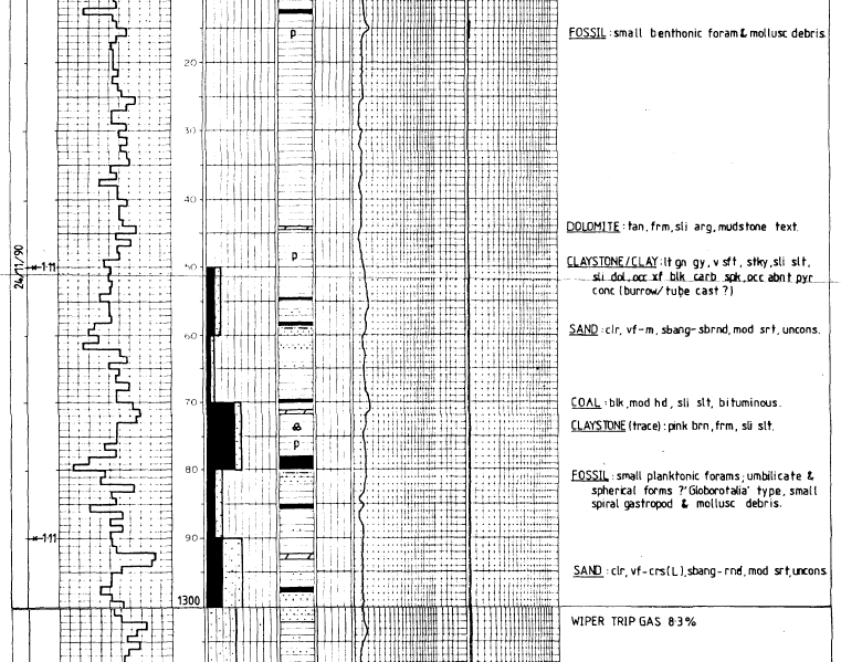
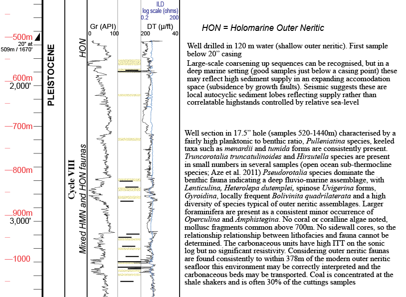
Even in a deeper marine facies, as in the well illustrated below, drilled in 120 water depth off the Baram Delta, the environment of deposition seems to fluctuate from middle neritic to deep outer neritic or even bathyal. Coaly material is brought into this setting and deposited as lignite beds along with inner neritic larger foraminifera, and there is a large degree of mixing of material redistributed by the changing sea-level.
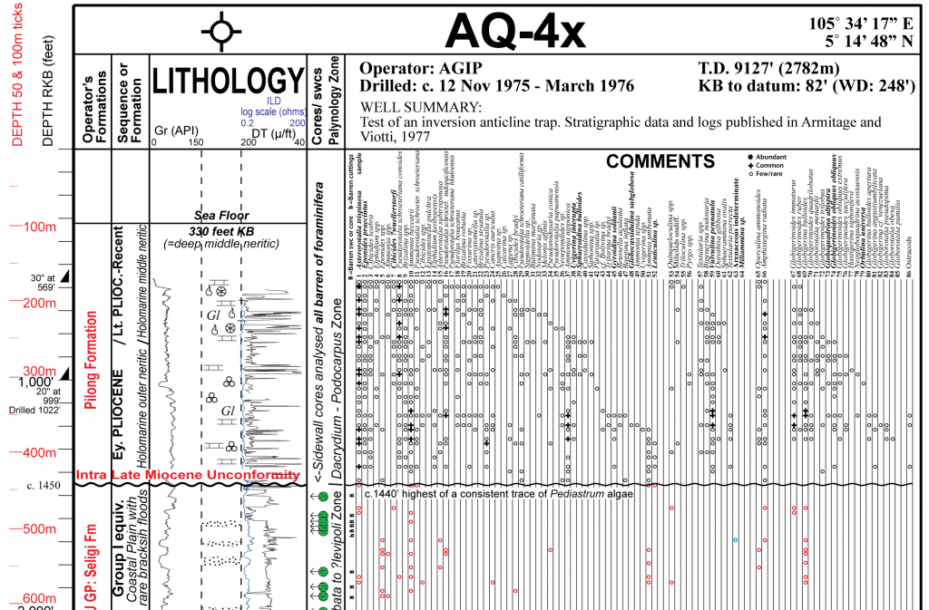
In an intermediate setting such as West Natuna, and the Pilong Formation (AQ-4x well, about 350 km SE of the study area of Miall in the Pliong Fm.) there is also strong mixing of different marine sedimentary components (original figure in Lunt, 2021).
Clearly what is going on here is repeated sea-level changes associated with eustasy and glaciation. A minimum 50 m variation is well within the expected range between glacial and interglacial periods. As long ago as 1949 Umbgrove pointed out there were drowned river systems under the Java Sea, now in 50 or 60 m of water. The important contrast is that the Early Pliocene and older beds lack this strong mixing of coaly beds, fluvial seismic features and adjacent clays with deep middle neritic faunas. Of course the mid Pliocene (start M2 oxygen isotope stage, 3.3 Ma Westerhold et al., 2020) was the onset of northern hemisphere glaciation, and this was an exaggeration of glacio-eustatic effects.
This gives us a benchmark. Do we see comparable contrasting lithofacies and fauna in the older sediments? Obviously they will not be as rapidly repeated and stacked, but many eustatic curves interpret sea-level changes of a magnitude comparable to the Late Pliocene to Recent events. (especially Haq et al. 1987; Haq and Al-Qahtani, 2005; see this link).
Also in the Malay Basin is the opposite extreme to the Late Pliocene to Pleistocene variability. After the first flood to brackish marine conditions across the southern Malay and West Natuna Basins, close to the Oligo-Miocene boundary, apparently a distal subsidence related to the major subsidence under the entire western South China Sea (break-up unconformity, and ridge-jump in sea floor spreading spreading; Barckhausen et al. 2014; Lunt, 2019; Lunt, 2021), there was about six or seven million years of sedimentary stasis. Over hundreds of square kilometres facies were brackish to freshwater but without any distinct marine floods. Strata with thin coal beds in Early Miocene Group I can be identified as a seismic facies in the southern Malay Basin, but its location does not significantly shift much either proximally or distally over this period. Marine floods, which would bring distinct macro- and microfauna, as sea water is two orders of magnitude richer in calcium to make calcite tests (see references cited in Lunt, 2021) are not seen. Very occasionally small acmes of nannofossils are noted, and it is possible these correlate to small marine floods, but marine inclusions of any magnitude or longevity are absent. This is in a sediment body consistently just above sea-level, not a land-locked, fluvial, Tonle Sap type setting (brackish Miliammina faunas are consistently present, as are fresh to brackish sphaerosiderite minerals). As transgressive sediments are very likely to be preserved below protective highstand units, one can only conclude that there were no rapid sea-level rises of five or ten meters (or more) that lasted any significant length of time, for almost the entire Early Miocene.
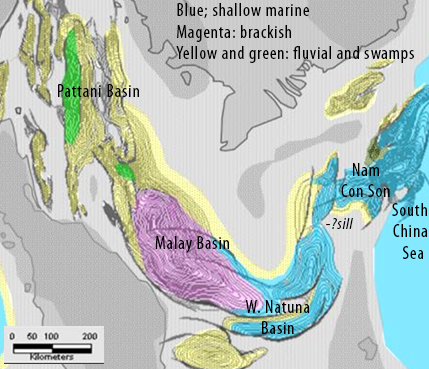
A facies gradation from Pattani in the north, through the Malay Basin, West Natuna Basin and Nam Con Son in the east can be recognised. The Dua Formation of Nam Con Son in the east is weakly marine in the majority of beds, Its equivalent in W. Natuna, the Arang Fm, consistently less marine, the Group I of southern Malay Basin, brackish, and north Malay to Pattani basins almost exclusively fluvial. This is some 500 km of lateral facies gradient lacking any sign of significant transgressive or regressive movement. This was one of the reason Shoup et al. (2012) suggested a physical sill might have been present in west Nam Con Son to retain and isolate such a large area of brackish conditions to the west.
I might be wrong. Better sampling than typical well cuttings samples might detect correlatable marine floods, but these will be small. What is clear is that for about six million years eustatic sea-level changes exerted no significant control on a uniquely sensitive sedimentary setting at sea-level. The Malay and West Natuna basins were affected again by tectonic movements during the Middle and Late Miocene (Mansor et al., 2014), and ceased to be such a sensitive setting to detect eustatic influence. Do we assume there was a different, stronger, glacio-eustatic control on sedimentation during the Middle and Late Miocene (on what evidence)? Or is it more likely eustatic changes were very minor and stratigraphically unimportant right up the the mid Pliocene onset of northern hemisphere glaciation?
References
Barckhausen, U., M. Engels, D. Franke, S. Ladage, and M. Pubellier., 2014, Evolution of the South China Sea: Revised ages for breakup and seafloor spreading. Marine and Petroleum Geology 58, 599-611.
van Gorsel, J. T., and S. R. Troelstra., 1981, Late Neogene planktonic foraminiferal biostratigraphy and climatostratigraphy of the Solo River section (Java, Indonesia). Marine Micropaleontology 6, 183-209.
Lunt, P., 2019, A new view of integrating stratigraphic and tectonic analysis in South China Sea and north Borneo basins. Journal of Asian Earth Sciences 177, 220-239.
Lunt, P., 2021, A reappraisal of the Cenozoic stratigraphy of the Malay and West Natuna Basins. Journal of Asian Earth Sciences: X 5, 100044.
Mansor, M. Y., A. H. A. Rahman, D. Menier, and M. Pubellier., 2014, Structural evolution of Malay Basin, its link to Sunda Block tectonics. Marine and Petroleum Geology 58, 736-748.
Miall, A. D., 2002, Architecture and sequence stratigraphy of Pleistocene fluvial systems in the Malay Basin, based on seismic time-slice analysis. AAPG Bulletin 86, no. 7: 1201-1216.
Shoup, R. C., R. J. Morley, T. Swiecicki, and S. Clark., 2012, Tectono-stratigraphic Framework and Tertiary Paleogeography of Southeast Asia: Gulf of Thailand to South Vietnam Shelf. Search and Discovery Article #30246
Umbgrove, Johannes Herman Frederik., 1949. Structural history of the East Indies. Cambridge: University Press. xi, 62, [1], X plates pp.
Westerhold, T., N. Marwan, A. J. Drury, D. Liebrand, C. Agnini, E. Anagnostou, J. S. K. Barnet, S. M. Bohaty, D. De Vleeschouwer, F. Florindo, T. Frederichs, D. A. Hodell, A. E. Holbourn, D. Kroon, V. Lauretano, K. Littler, L. J. Lourens, M. Lyle, H. Pälike, U. Röhl, J. Tian, R. H. Wilkens, P. A. Wilson, and J. C. Zachos., 2020, An astronomically dated record of Earth’s climate and its predictability over the last 66 million years. Science 369, no. 6509: 1383-1387.
Be First to Comment