One of the reasons I began this blog was as a way to pass on ideas (right or wrong) to fellow geologists and the next generation. Something I have been asked a couple of times is “what is the island of Java?”, so this seems a reasonable excuse for a post. At least two people might find this interesting.
Many geologists have the impression that Java is above a back-arc basin, and therefore the process and mechanics of subduction are an integral part of the geological history of the island. I think the data says otherwise. For a start there is a line that follows the north coast of the island, as well as Madura and Kangean islands to the east, and north of this line is one type of geology, and south of it another. The geology to the south, under Java, is:
- (A) Much other – as old as Paleocene in places, but commonly Middle Eocene so at least 45 Ma, as opposed to intra Oligocene to Recent to the north (only about 30 Ma of sedimentary history).
- (B) The geology to the south is dynamic (e.g. the Rajamandala reefal limestone in west Java overlays uplifted bathyal clays, then was buried by deep marine volcaniclastics, and has been uplifted to outcrop today). The north is passive and layer-cake.
- (C) South of the line (in the east historically called the Rembang Line) the sediments are much thicker than to the north; much more so than would expected by simply having an additional 15 Ma of stratigraphic history present.
The geology to the south, under the island of Java shows so much movement, and often different polarities of movement at the same times of change, it strong suggests wrench movement, with “pop-up” and “pop-down” features. It is also important to note that the timing of these movements are episodic and have the same timing as regional tectonic events. In my 2013 tome (The sedimentary geology of Java) I remarked how BP had developed a scheme in the far eastern Java area, north of Bali and Lombok, that matched my own scheme for the island of Java. I discussed this with the biostratigrapher advising the BP team (Antoine Wonders; the papers were by Steve Matthews and Paul Bransden; 1992, 1995) and found we had independently observed the same unconformities over 1200 km from West Java to north of Lombok, but this was a totally different history to the Java Sea wells on the coast or just a few kilometres immediately north of the island!
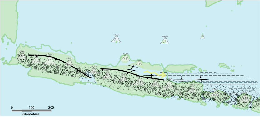
These island-wide faults were active at many times, with the intra Late Miocene uplift of the Rembang – Madura – Kangean zone at roughly 8 Ma being one of the strongest movements. At about 3.5 Ma was the first deviation from the transpressive forces as there was overthrusting from the south. This created the Kendeng Zone of East Java, which exposed rock as old as Early Oligocene around the Central to East Java border. Thrusting was seen across the island north of the volcanic chain, but in the western half of the island no really old rocks were uplifted, and the thrusts could be at least in part due to volcanic loading on thick clastic successions. As van Bemmelen said about Mt. Ciremai; an unstable “giant on feet of loam”.
Some workers (deCelles and Giles, 1996) had suggested that the Java basins were partly “retro-arc foreland basins”. This misses the importance of history. The overthrusting occupies only a very minor, young, proportion of a much longer history. The very thick Early Pliocene to Eocene sections were not deposited in an accommodation space created by foreland loading.
As I mentioned in my 2019 paper, and with additional work in press, I do not believe any of the Java basins are back arc basins. The Makassar Straits opened in stages and these stages correlate to the stage of fault movement across Java and under the Java Sea. Faults bounding the Central Deep and most other lows in the Java Sea trend NE to SW, parallel to the Makassar Straits (see maps below), and are not oriented to the E-W subduction trend that should have north to south roll-back extension. The marine transgression out of the axis of the Makassar Straits proceeds from east to west, in stages up until the regional tectonic events on the Oligo-Miocene boundary when the entire Java Sea platform was flooded.
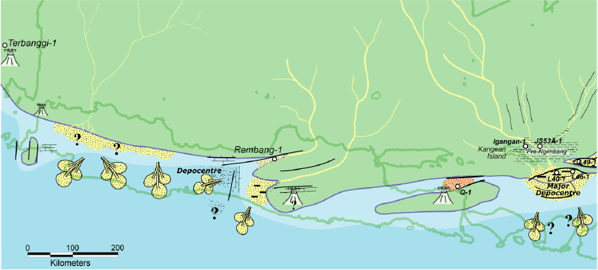
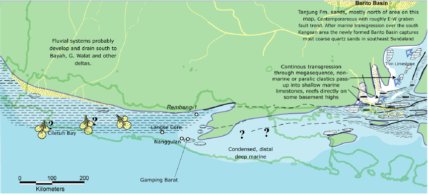
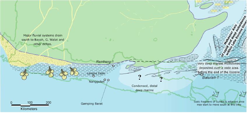
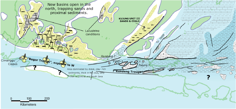
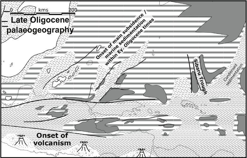
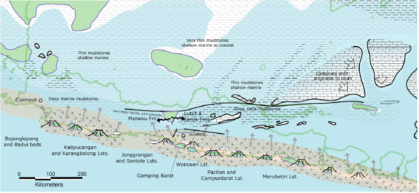
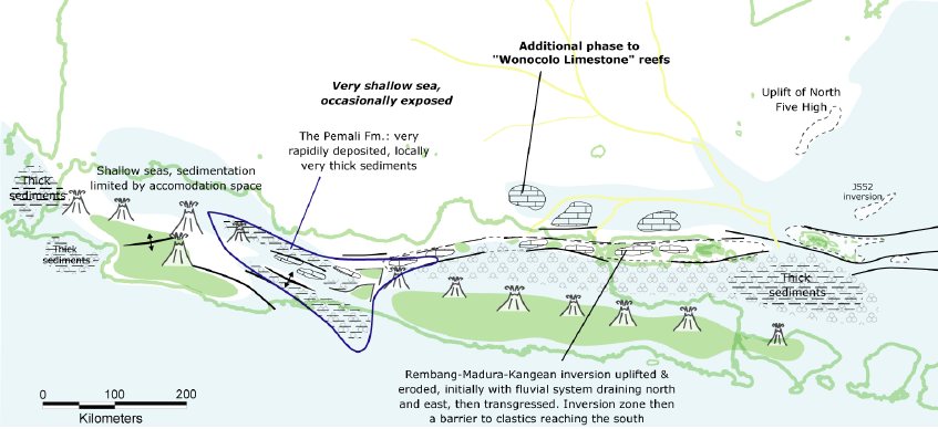
With the exception of the 3.5 Ma, mid-Pliocene, thrusting there is nothing that is consistent with the stratigraphy expected in back-arc basins. The following figures are taken from Lunt (2013) but are slightly out of date. One important error, corrected in my 2019 paper, is the Sibaru Trough in the area north of Kangean Island. This feature was created in mid-Oligocene times by the uplift of two new bounding highs.
An outstanding mystery is what caused the mid-Pliocene thrusting? From its focus south of the town of Semarang it gradually fades eastwards and changes into a series of folds in the southern Madura Straits (with vertical displacement, between onshore areas and offshore basins, being mostly due to isostatic loading). The whole structural story is a lovely project for a structural geologist, but the person would need good stratigraphic control, and the stratigraphers have been asleep on the job for 25 years. In my 2013 tome (see page 312) I speculated on how the Early Oligocene (Letter Stage Tc), quartz rich turbidites of the Cikalong Beds in west Java could have been deposited, as all shallow marine Early Oligocene (Tc) siliciclastics to the north were rich in volcanic sands and conglomerates, and devoid of quartz. The only possible source, I guessed, was uplift of the Ciletuh Fm. Eocene quartz sands to the south of Cikalong. Such basic anomalies such as this, from areas with a days drive of Jakarta, should have been sorted out – or at least recorded – a long time ago.
No, southeast Asia is not well-explored or well-understood.


References
Bransden, P. J. E., and S. J. Matthews., 1992, Structural and stratigraphic evolution of the East Java Sea, Indonesia. Proceedings Indonesian Petroleum Association Convention 21, 417-454.
DeCelles, P. G., and K. A. Giles., 1996, Foreland basins systems. Basin Research 8, 105-123.
Luan, X., and P. Lunt., 2021, Eocene to Miocene stratigraphic controls in the far East Java Sea: Implications for stratigraphic studies. Marine Geology
Lunt, P., 2013. The sedimentary geology of Java. Special Publication. Jakarta: Indonesian Petroleum Association. 346 pp.
Lunt, P., 2019, The origin of the East Java Sea basins deduced from sequence stratigraphy. Marine and Petroleum Geology 105, 17-31.
Lunt, P., and J. T. van Gorsel., 2013, Geohistory analysis of South Makassar. Berita Sedimentologi 28, 14-52.
Matthews, S. J., and P. J. E. Bransden., 1995, Late Cretaceous and Cenozoic tectono-stratigraphic developments of the East Java Sea Basin, Indonesia. Marine and Petroleum Geology 12, no. 5: 499-510.
Be First to Comment