Eocene to Miocene stratigraphic controls in the far east Java Sea: Implications for stratigraphic studies
With Xiwu Luan. Published 2021, Marine Geology
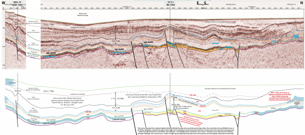
This was a simple paper that took a seismic line in the area where the far eastern Java Sea merges into the southern Makassar Straits and compared it to an old line in a publication. This was a 1992 paper by Bartek, Vail and others, published the same year that BP drilled a new well in the area (ST Z-1) and carried out their usual thorough analytical program. The Bartek et al. paper observed a prograding clinoform (actually of carbonate material derived from the siliciclastic-starved Doang Platform) and correlated this to a global Neogene eustatic sea-level curve, as one of several examples supposedly demonstrating that the eustatic sea-level signature was visible “even in tectonically active areas” (the Doang Platform in the Neogene was hardly tectonically active!).
The BP well proved otherwise. The clinoform was of a significantly different age to that interpreted by Bartek et al. A review of the entire Palaeogene through Neogene section reveals the stratigraphy was always controlled by tectonism, which included multiple subsidence unconformities. These are seen in well sections as multiple non-Waltherian contacts, where very deep facies abruptly overly very shallow marine or non-marine facies.

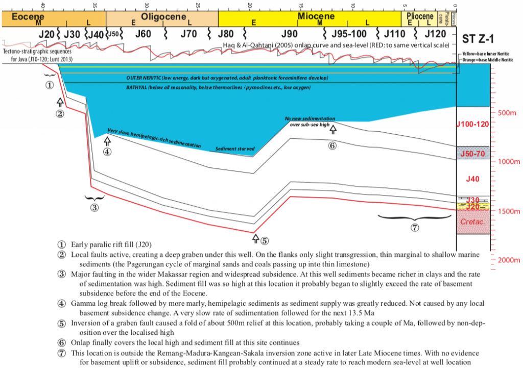
The rapid nature of change at these non-Waltherian contacts in this area are also described in a related blog post. These tectonic events, which caused rapid migration of entire sedimentary systems, are the natural sequence stratigraphic boundaries in the region. The subsidence history, examined using geohistory analysis of the ST Z-1, is highly instructive and correlates with prior geohistory analysis done to the north by Lunt and van Gorsel (2013). After the sequence boundary on the Eocene-Oligocene boundary the ST Z-1 location was sediment-starved and isostatic loading was negligible. The increase in accommodation space from paralic to middle bathyal conditions (the well was drilled in nearly 500m water depth) was achieved in about four million years through three main tectonic changes (at roughly 38, 36 and 34 Ma). The Haq and Al-Qahtani (2005) sea-level curve is drawn to scale on the top of the geohistory plot and it is insignificant compared to the scale of the tectonic changes to accommodation space.
The seismic line for this paper was split into three panels for the page-size figures. A high resolution, single page version is available from me

The same area is also discussed in a new paper on “Controls on Early Miocene carbonate and siliciclastic deposition in eastern Java and south Makassar Straits”, and the overview paper “The Oligo-Miocene boundary unconformity around Sundaland (SE Asia); changes to the regional tectonic model.”
References
Bartek, L.R., Vail, P.R., Anderson, J.B., Emmet, A., Wu, S., 1991. Effect of Cenozoic ice sheet fluctuations in Antarctica on the stratigraphic signature of the Neogene. Journal of Geophysical Research 96(B4), 6753-6778
Haq, B.U., Al-Qahtani, A.M., 2005. Phanerozoic cycles of sea-level change on the Arabian Platform. GeoArabia 10, 127-160
Lunt, P., van Gorsel, J.T., 2013. Geohistory analysis of South Makassar. Berita Sedimentologi 28, 14-52
Be First to Comment