Lunt, P., 2019. A new view of integrating stratigraphic and tectonic analysis in South China Sea and north Borneo basins. Journal of Asian Earth Sciences 177, 220-239 DOI: https://doi.org/10.1016/j.jseaes.2019.03.009
This was a very rapidly written paper as Manuel Pubellier asked me for a contribution just a month or so before the deadline to a special Journal of Asia Earth Sciences issue on the South China Sea. The main aim was to contribute some stratigraphic control to the events observed on seismic and often mis-calibrated. I tool a figure of Franke et al. (2014) and re-calibrated the unconformities around the South China Sea based on modern well, ODP and outcrop data. Locations such as the Paracel (Xisha) Islands required a paper published in 2018 (Ma et al.) but Nam Con Son, Pearl River Mouth Basin (seismically tied to ODP 1148), NW Borneo, Reed Bank and Palawan have well data I had work on from original repots, and I could add SW Borneo (Sarawak).
I also noted that large areas offshore Sarawak must have had plate attenuation during the Late Oligocene (on the wrong side of the West Baram Line to have been associated with a Proto-South China Sea slab pull force (Hall and Brietfeld, 2017). I forgot the 1956 Selungun-1 and 1952 Subis-2 wells onshore Sarawak which also had very thick (>2 km), very rapidly deposited siliciclastics of Late Oligocene age (based on larger foraminifera and post-drill nannofossil data on Selungun-1). All deposited in a paralic to very shallow marine setting.
In this 2019 paper I published the Mulu-1 geohistory (with the nearby Kekek-1 added to complete the section to Cycle I), calculated using the BackStrip software and placing the output below a template in Adobe Illustrator to draw over. A very cumbersome method now replaced by Novva from Sirius GCX. Sadly I forgot to plot tectonic vs isostatic driven subsidence. However for the purposes of this paper it showed how the transition from a delta-plain deposit must have been due to extremely fast and large subsidence in order to create the accommodation space for nearly 2 km of bathyal claystones (c. 2.5 km adjusted for later compaction), shallowing up to inner neritic clastics. Proof that this fill returned to near sea-level is the reef shown in Hutchison (2004; Figure 7) and drilled in 2015 by the Tuntong-1 well. The reef very rapidly subsided to deep marine conditions; literally drowned by the high rate of subsidence. Reefs to the south, with slightly less subsidence, survived as the high relief pinnacles of the Luconia carbonates, but the rest of the Mulu horst was slowly covered by condensed hemipelagic chalks for the next 7 or 8 million years. This Tuntong reef, at sea-level about 14 million years ago, is now 3 km below sea-level. About half of this was due to isostatic loading as Pliocene siliciclastics later covered the North Luconia area. This feature is shown in new versions of the Mulu geohistory plot (see the figure on this page, reproduced below), drawn with tectonic subsidence separated from isostatic loading.
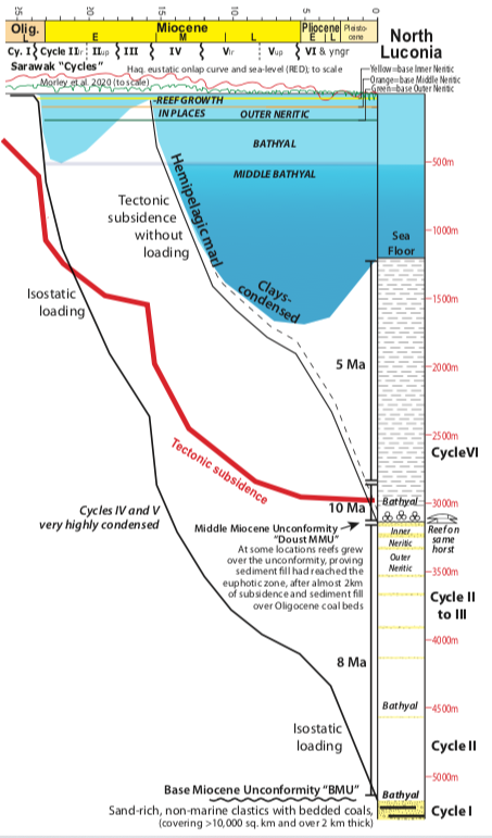
The key point in this 2019 paper was to show these two massive subsidence events at Mulu, with good estimates of scale and rate of change, compared to the Haq and Al-Qahtani (2005) sea level curve shown in red at the top of this plot. There is almost two orders of magnitude difference between the accommodation space created by proposed eustatic changes, and those observed not just in this well but other nearby wells created by tectonism (e.g. the Paus stucture in Figure 11 of the 2019 paper).
A later geohistory plot of G10-1 in the 2019 paper I have also modified slightly, but it shows a curious contrast between the rapidly deposited Late Oligocene, then an event at the Oligo-Miocene boundary (there is local tilting on seismic) and the Miocene pinnacle reef. The basement subsidence actually decreased at the Oligo-Miocene boundary, contrasting with the massive increase in subsidence at Mulu situated in the graben to the northwest. This was not a simple planar re-adjustment to accommodation space but something far more complex, and a feature that requires geohistory to identify and measure.
As usual several other points are chucked into this paper. I have been criticised for poor organisation of ideas when I write, which is a fair criticism. I am often more concerned at, having got outline permission to release data, getting as many observations included as I can.
The better constrained data in offshore Sarawak can be correlated to Pearl River Mouth Basin, Paracel/ Xisha Islands, Palawan and north Borneo data and as predicted by Franke et al., the break-up of the South China Sea was diachronous, but clearly shown to have been in pulsed steps migrating westwards through time. The direction of the axis of spreading also rotated in steps.
References
Franke, D., Savva, D., Pubellier, M., Steuer, S., Mouly, B., Auxietre, J.-L., Meresse, F., Chamot-Rooke, N., 2014. The final rifting evolution in the South China Sea. Marine and Petroleum Geology: Evolution, Structure, and Sedimentary Record of the South China Sea and Adjacent Basins 58, 704-720
Hall, R., Breitfeld, T.H., 2017. Nature and demise of the Proto-South China Sea. Geological Society Malaysia Bulletin 63, 61-76
Hutchison, C.S., 2004. Marginal basin evolution: the southern South China Sea. Marine and Petroleum Geology 21, 1129-1148
Ma, Z.-L., Li, Q.-Y., Liu, X.-Y., Luo, W., Zhang, D.-J., Zhu, Y.-H., 2018. Palaeoenvironmental significance of Miocene larger benthic foraminifera from the Xisha Islands, South China Sea. Palaeoworld 27(1), 145-157
Be First to Comment