This post accompanies notes on the Proto-South China Sea Part 1 and Part 2
There is one circumstantial line of evidence that has been used to suggest a Proto-South China Sea (PSCS) slab-pull model for the development of the South China Sea (SCS), and that is the geometry of the blocks and size of gaps in the SCS, and the location and lateral throw of major wrench faults. These do not appear to add up, so by having a disappearing PSCS oceanic plate (of unknown size) these values can be made to balance. This was the theme of many papers such as Clift et al. (2008) and Mazur et al. (2012). These types of papers make many assumptions about the palaeogeography prior to Oligocene sea-floor spreading and contain almost no consideration of local geology or stratigraphy, which undermines the cases they make for plate reconstructions. If some stratigraphy is included in the reports, such as interpreted seismic lines (e.g. Clift et al.) the control on the interpretations is not auditable, and there is the persistent mis-calibration of major unconformities (MMU and DRU), and rarely any mention of the dominant Base Miocene Unconformity event.
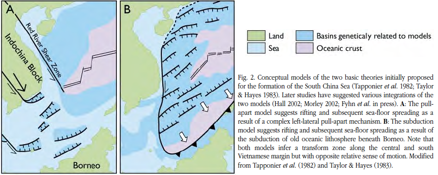
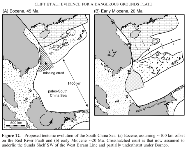
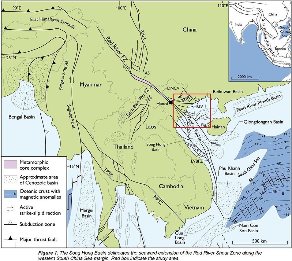
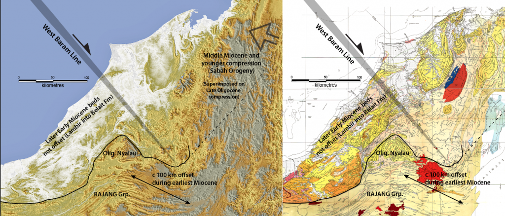
The main problem is at the wide end of the V-shaped wedge of mid-Cenozoic oceanic crust formed by drift, which has a gap of about 800km. However, this is unambiguously a tapered V of new oceanic crust, and at the narrow end in the SW it has only a minimal earliest Miocene spreading of c. 100km – roughly the same as the folded offset of Oligocene beds onshore Sarawak (overlain by later Early Miocene Lambir Fm. deposited after the wrench folding; see maps below). In this SW SCS area the amount of rifted crustal attenuation (stretching) is probably similar to the amount of earliest Miocene sea-floor spreading.
A new summary of the geometry problem
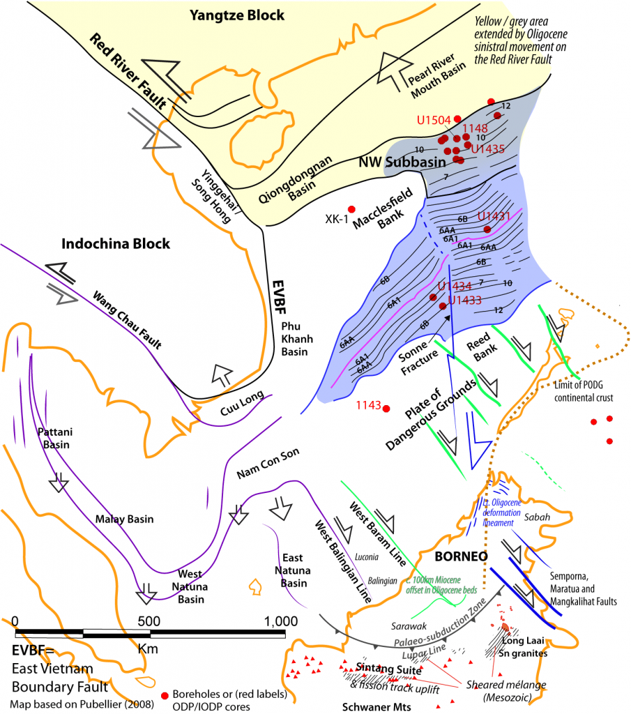
The geometry problem can be resolved in three parts. First the eastern end of the SCS, and especially the northern side, has long been recognised as having an older spreading history. There was base Oligocene (Chron C12) spreading lasting until mid-Oligocene (C10), at which time the NW Subbasin was formed, extending west into the Qiongdongnan Basin. It is thought that the 28-28½ Ma unconformity reflected the start of more symmetrical spreading and the spreading ridge began to migrate southwards (Barckhausen et al., 2014, Figure 9) This separated the Macclesfield Bank from the Reed Bank, and this southward motion of the eastern portion of the Plate of Dangerous Grounds (PODG) is thought to have begun the movement that led to latest Oligocene compression in northern Borneo (blue lineaments on map above). However up until 28-28½ Ma all sea-floor spreading had been in the north, and this could have been compensated entirely by left-lateral wrenching on the Red River Fault. This means that about 200-250 km of spreading can be subtracted from the total of 800 km.
Drift exclusively east of the Sonne Fracture continued up until the early part of Chron C6B (Oligo-Miocene boundary at c. 24 Ma) when spreading “jumped” west (ridge jump) and began sea-floor spreading in the central SCS (Barckhausen et al, 2014). In total about 400-450 m of sea-floor spreading occurred exclusively east of the Sonne Fracture Zone. While 200-250 km can be excluded due to the sinistral RRF movement, the remaining 200 km southwards movement of the eastern Dangerous Ground plate south of the spreading centre had to go somewhere. On the NE side of Borneo the Semporna, Maratua and Mangkalihat wrench faults are suspected to have been active in the Palaeogene as their periodic movement is associated with the initiation, migration and termination of reefal limestones on their flanks (Seilor and Taballar Limestones; Lunt and Woodroof, 2021). The compound wrenching of several faults may not be needed to absorb the entire 200 km of displacement as the old palaeosubduction zone from Mesozoic subduction and collision is in this area (an extension of the Lupar Line, south of which there are Mesozoic sheared mélanges). There could have been reactivated movement of this previously incomplete subduction (Moss, 1998), and this might explain the onset of the Sintang Suite igneous extrusions in west Borneo and the Long Laai granite intrusion in NE Borneo (both dated as latest Oligocene and earliest Miocene, Setiawan and Le Bel, 1988; Prouteau et al., 2001 – the same time as fission track dating of uplift south of the Lupar Line in west central Borneo; Moss et al., 1998).
Second. The sea-floor spreading in the central area after ridge jump at c 24 Ma has the most strongly tapered V profile. Undoubtedly there was some kind of rotation of areas south of the spreading center, and this could have included wrench movement on NW to SE faults (as mapped by Schluter et al., 1996). As mentioned above one of these faults was the West Baram Line that can be seen to have sinistrally displaced Oligocene beds by 90-100 km onshore Borneo. These faults have the same trend as the Semporna, Maratua and Mangkalihat Faults, but there is no evidence that these NE Borneo faults moved during earliest Miocene times. (A post on the rotation of Borneo is here)
Thirdly, the entire Sundaland region is known to have gradually subsided and was transgressed from Late Eocene through Early Miocene times (a sea-level rise while global sea-level was gradually falling). The effect is seen in both the eastern areas as well as in the west, in the Malay, West Natuna, Nam Con Son and Cuu Long Basins. These were the loci of extensions that, while small on a scale of plate attenuation, would have contributed a few tens of kilometres southward movement to match modest extension in the SW SCS. This is a continuation of the taper, or diminishment, of spreading westwards. Dating older movements in the western basins is difficult as most older facies are non-marine, but the major ridge jump and spreading on the Oligo-Miocene boundary can be precisely correlated with the first marine or brackish transgression into Cuu Long, Nam Con Son, West Natuna and Malay Basins (Lunt, 2021a), indicating a temporal, spatial and geometric link between these processes. It was also the subsidence and transgression of the East Natuna area.
Review of competing models
Laid out like this there is very little issue matching tectonic blocks from opposite sides of the SCS sea-floor spreading. It is complex, with shearing and rotation of the PODG, and a NE to SW diminishment of effect. The problem is that it matches neither existing slab-pull (PSCS) or extrusion models. There is no stratigraphic history associated with the speculated PSCS subduction and collision. One cannot move plates, have a collision, and not leave a stratigraphic signature. Apparent symptoms of such a history in NW Borneo and Palawan are invariably mis-dated and nothing to do with movement of the SCS plates. In the absence of any tomographic evidence for the subduction zone (Lin et al., 2020) we are forced to consider alternative mechanisms. It could be argued that the slab-pull effect has simply moved south and is re-activation of the old Mesozoic subduction. However, this does not account for the strongly tapered form of the Oligocene to earliest Miocene extension, and while some uplift is indicated by stratigraphic data in these areas there is no evidence for renewed accretion, sheared mélanges and so on, so any plate movement is likely to have been of limited magnitude.
The extrusion model of Tapponnier et al. (1982) suggested left-lateral wrenching moved a southerly block away from the Yangtze plate, leaving a gap that would become the South China Sea. Slight rotation was implied as the Indian plate further deformed Asia and pushed the Yangtze Block away from Borneo. This clearly is not the whole story, as the southern movement of the eastern Plate of Dangerous Grounds (PODG) caused considerable latest Oligocene compression across northern Borneo, which was long regarded as the greatest Cenozoic orogeny to have affected that area. Across Sundaland extension and subsidence dominated geology through the Late Eocene through Early Miocene, apart from this north Borneo compression and one other instance along the West Balingian Line that saw rapid but locally strong uplift also in the latest Oligocene (Lunt and Madon, 2017). Both of these deformations were terminated on the Oligo-Miocene boundary just as sea-floor spreading abruptly migrated (“ridge jump”) into the central SCS. This was immediately followed by substantial subsidence even in the deformed NW Borneo (see Lunt, 2021b). As noted above, it appears that Oligocene and older beds in north Sarawak were tightly folded in the earliest Miocene by sinistral movement along an extension of the West Baram Line. These instances of compression do not fit the relatively passive differential dragging of plates by extrusion wrenching. In this model there is no source for a force to cause an orogeny across northern Borneo.
Speculation on a new model
It is apparent that a force both attenuated and then split the SCS, and this force also drove the eastern PODG into northern Borneo. This force was strongest in the east and diminished westwards. This plate-driving force also seems to have affected the Makassar Straits at the same time, with simultaneous sudden extension and subsidence in both areas, and with largest / earliest effects in the east, diminishing westwards (Luan and Lunt, in press). The correlation in time is quite precise, and these are the main basin defining events in both areas, as Sundaland gradually subsided and was transgressed (while global sea-levels were falling). An event on the Eocene-Oligocene boundary (34 Ma) is well-dated by the mass extinction at that time. A mid Oligocene event at 28-28½ Ma is less precisely dated, except in IODP cores, but it is the sole large-scale unconformity in both areas within the ten million year duration of the Oligocene. In addition a very widespread extension / subsidence event on the Oligo-Miocene boundary is also well dated in marine and non-marine facies. A much larger scale plate force is required for this than subduction of the PSCS. [A less important point of scale was pointed out by Lunt (2019) as the attenuation of the entire offshore Sarawak, Balingian through Luconia areas, during the Oligocene, west of the West Baram Line cannot be explained by the proposed subduction of the PSCS.]
The fact that the force was active in north Borneo after onset of sea-floor spreading means that the source cannot be linked to stress in the lithosphere, which was broken by the transition from rift to drift. Gravity slab-pull is disregarded in the text above, so this leaves asthenosphere movement and traction from the moving asthenosphere to the base of the lithosphere. Considering the timing, form and geometry of movement, and the apparent role for some wrenching on the RRF and Wang Chau Faults, the extrusion principle could still be valid, but the prime body being extruded would have beeb the plastic / solid upper asthenosphere and this then exerted a force on the shallower mantle and crustal lithosphere? This roughly NNW to SSE migration within the mantle would be of sufficient scale to affect the entire Sundaland plate, including widespread attenuation and subsidence. The mountains of west Vietnam and Loas continuing into SW China, and ultimately the Himalayas, would have been compressive and resisted lateral movement over time, but a deeper counter-flow migration of mantle in the east would have had less resistance. The only problem I can see with such a model is how such a movement within the upper mantle would have interacted with the oceanic plate that was subducting below southern Java, which should have been a barrier. However as Australian micro-plates approached in Early Miocene times there was a corresponding termination of the attenuation and subsidence of Sundaland, so perhaps there is a single mechanism such as this, with details we have yet to work out.
Whatever the outcome of future work, it is clear that stratigraphers have left a very poor record of the large scale development of basins and their sedimentary fill (e.g. the awful mis-representation of DRUs MMUs and the major BMU missing from most work). Interpretation of seismic is not stratigraphy without the supporting data, and especially without geohistory analysis. With proper audit, geohistory will track subsidence histories (tectonic and isostatic) and the geographic variation in these properties. Basic stratigraphy will illustrate the long-term subsidence of Sundaland, but good stratigraphy will show that the subsidence consisted of very sudden times of acceleration. This is important as it indicates that this basin-forming process probably had a source in the crustal lithosphere, as only faulting and isostatic adjustment can create such sudden and extreme changes in accommodation space and palaeobathymetry.
References
Barckhausen, U., Engels, M., Franke, D., Ladage, S., Pubellier, M., 2014. Evolution of the South China Sea: Revised ages for breakup and seafloor spreading. Marine and Petroleum Geology 58, 599-611
Clift, P., Lee, G.H., Anh Duc, N., Barckhausen, U., Van Long, H., Zhen, S., 2008. Seismic reflection evidence for a Dangerous Grounds miniplate: No extrusion origin for the South China Sea. Tectonics 27(3)
Fyhn, M.B., Nielsen, L.H., Boldreel, L.O., 2007. Cenozoic evolution of the Vietnamese coastal margin. Geological Survey of Denmark and Greenland Bulletin 13, 73-76
Fyhn, M.B., Nielsen, L.H., Hovikoski, J., Therkelsen, J., Petersen, H.I., Abatzis, I., 2015. Complex Cainozoic Rifting and Pulsed Inversion in the Northern Song Hong Basin, Vietnam. Proceedings from AAPG Datapages Search and Discovery Article #90236apr: 1-3
Hall, R., Breitfeld, T.H., 2017. Nature and demise of the Proto-South China Sea. Geological Society Malaysia Bulletin 63, 61-76
Liechti, P., 1960. The geology of Sarawak, Brunei and the western part of North Borneo (Bulletin 3). Kuching Sarawak: Geological Survey Department British Territories in Borneo.
Lin, Y.-A., Colli, L., Wu, J., Schuberth, B.S.A., 2020. Where Are the Proto-South China Sea Slabs? SE Asian Plate Tectonics and Mantle Flow History From Global Mantle Convection Modeling. Journal of Geophysical Research: Solid Earth J. Geophys. Res. Solid Earth 125(12), e2020JB019758
Luan, X., Lunt, P., in press. Controls on Early Miocene carbonate and siliciclastic deposition in eastern Java and south Makassar Straits, Indonesia. Journal of Asian Earth Sciences,
Lunt, P., 2019. A new view of integrating stratigraphic and tectonic analysis in South China Sea and north Borneo basins. Journal of Asian Earth Sciences 177, 220-239
Lunt, P., 2021a. A reappraisal of the Cenozoic stratigraphy of the Malay and West Natuna Basins. Journal of Asian Earth Sciences: X 5, 100044
Lunt, P., 2021b. Re-examination of the Base Miocene Unconformity in West Sabah and its part in the tectono-stratigraphic development of the region. Journal of Asian Earth Sciences,
Lunt, P., Madon, M.B.H., 2017. A review of the Sarawak Cycles: History and modern application. Geological Society Malaysia Bulletin 63, 77-101
Lunt, P., Woodroof, P., 2021. Tectono-stratigraphic controls on Cenozoic SE Asian carbonates. SEPM Special publication, Cenozoic Isolated Carbonate Platforms – Focus Southeast Asia,
Mazur, S., Green, C., Stewart, M.G., Whittaker, J.M., Williams, S., 2012. Displacement along the Red River Fault constrained by extension estimates and plate reconstructions. Tectonics 31, 1-22
Moss, S.J., 1998. Embaluh Group turbidites in Kalimantan: Evolution of a remnant oceanic basin in Borneo during the Late Cretaceous and Palaeogene. /. Geol. Soc. London, 155, 509- 524.
Moss, S.J., A. Carter, S. Baker, and A.J. Hurford. 1998. A Late Oligocene tectono-volcanic event in East Kalimantan and the implications for tectonics and sedimentation in Borneo. Journal of the Geological Society 155, 177-192.
Prouteau, G., R.C.M., Pubellie, M., Cotten, J., Bellon, H., 2001. Le magmatisme post-collisionnel du Nord-Ouest de Borneo, produit de la fusion d’un fragment de croute oceanique ancre dans le manteau superieur. Bulletin de la Societe Geologique de France 172(3), 319-332
Pubellier, M., 2008. Structural Map of Eastern Eurasia (1:12 500 500). Commission for the Geological Map of the World (with UNESCO and Total)
Schlüter, H.U., Hinz, K., Block, M., 1996. Tectono-stratigraphic terranes and detachment faulting of the South China Sea and Sulu Sea. Marine Geology 130, 39-78
Setiawan, B., LeBel, L.M., 1988. Discovery of a new tin province, Long Lai area, East Kalimantan, Indonesia. In C. S. Hutchison (Ed.), Exploration and evaluation techniques for tin-tungsten granites in SE Asia and the Western Pacific region, 61-88. Ipoh, Malaysia: Proceedings of IGCP project 220 conference.
Tapponnier, P., Peltzer, G., LeDain, A.Y., Armijo, R., Cobbold, P., 1982. Propogation extrusion tectonics in Asia: new insights from simple experiments with plasticine. Geology 10, 611-616
Be First to Comment