Lunt, P., 2019. Partitioned transtensional Cenozoic stratigraphic development of North Sumatra. Marine and Petroleum Geology 106, 1-16. DOI: https://doi.org/10.1016/j.marpetgeo.2019.04.031
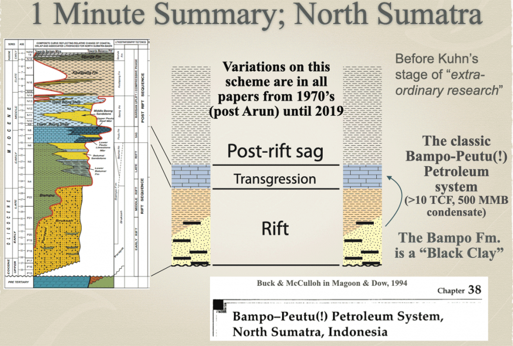
A paper with two aims. First try to kill some entrenched ideas unsupported in the literature such as the Tampur Limestone being Eocene (it is pre-Cenozoic, but very poorly fossiliferous), and the black clays of the deep marine Pirak Fm. not being the same as the black clays of the Bampo Formation. They are not even the same age – even though no one has been back to the type location of the Bampo Fm for decades. They just visit the location of Pirak clays instead and call them “Bampo”. Childishly simple stuff like this.
Oh yes, and the pre-“black clay” sands of the NW region – the Agam Formation of early Oligocene age – are not the Early Miocene Parapat Formation sands below the Bampo Fm black clays in wells drilled in the east. And to add another level of confusion, some workers had even shown the type Parapat Formation near Lake Toba was not the same as the sands below the Bampo Fm in wells eastern North Sumatra, so even this was the wrong name – but industry reports still used “Parapat Fm.” for a couple of decades afterwards.
When you read what other sciences are up to (like advancing) and then come across repeated silliness like this, it can be quite depressing. As you may read in the text of the paper, it is hard to write all this up and stay sensible and clam (and avoid sarcasm). To me it is symptomatic that good stratigraphers are now few, and far between. People who can think in a slightly abstract way of observations in space and time, frameworks that cannot break Walther’s law, and conform to rules on naming (chronostratigraphy vs geochronology). Nowadays most stratigraphers just colour in seismic, add a sprinkling of jargon, and forget the dimensions of facies and time, and the rules that constrain them. Geohistory forces you to think in a more integrated way, without getting lost in jargon and rules of names.
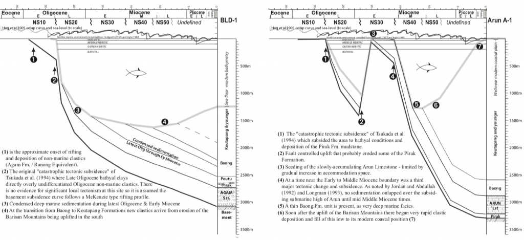
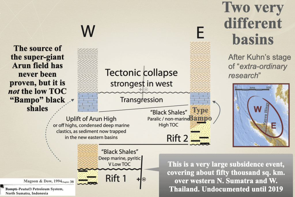
The second aim of the paper was to portray the North Sumatra areas as two very distinct basins with different histories and petroleum systems elements. The geohistory plots were an idea way to do this and could graphically illustrate the extreme variation in accommodation space I had recognised when working on the BLD-1 well, and which could be correlated into west Thailand (data I only saw a couple of years after BLD-1) and Mobil’s onshore Aceh fieldwork.

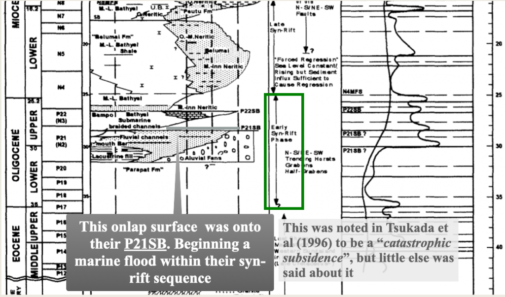
Back in 1997 I persuaded Tsukada-san to mention the “Catastrophic subsidence” seen in the good core and sidewall core material in BLD-1 and ITU-1 wells. However the corporate stratigraphic chart survived into the IPA paper, scaled against the prevailing Haq sea-level curve, with sequence boundaries “P21SB” and “P22SB” (see image below). On the geohistory plots for this paper I added the Haq sea-level curve at the same scale at the top of the plot (modern sl =0). The Haq eustatic sea-level control on accommodation space is very small compared to the enormous subsidence observed over 50,000 sq.km from onshore Aceh to offshore west Thailand in mid-Oligocene times. This was a sea-level rise when global models suggested there should have been the largest eustatic sea-level fall of the Cenozoic. What is more, as the paper points out, this subsidence was temporarily reversed at Arun a few million years later so that the Early Miocene reef of the supergiant field could form on a substrate of Late Oligocene bathyal clays.

You would think that after some 14 TCF of gas and 500 million barrels of condensate Mobil might know a little more about the basic geology of the area?!
There’s that sarcasm creeping in! But I would say it is well-deserved mockery. Why is the science of geology not advancing? It is because we are not trying.


References
Tsukada, K., Fuse, A., Kato, W., Honda, H., Abdullah, M., Wamsteeker, L., Sulaeman, A., Bon, J., 1996. Sequence stratigraphy of the North Aceh offshore area, North Sumatra, Indonesia. Proceedings from Proceedings Indonesian Petroleum Association Convention: 25, 29–41
Be First to Comment