See also: Evidence on the speed of tectono-stratigraphic change -1
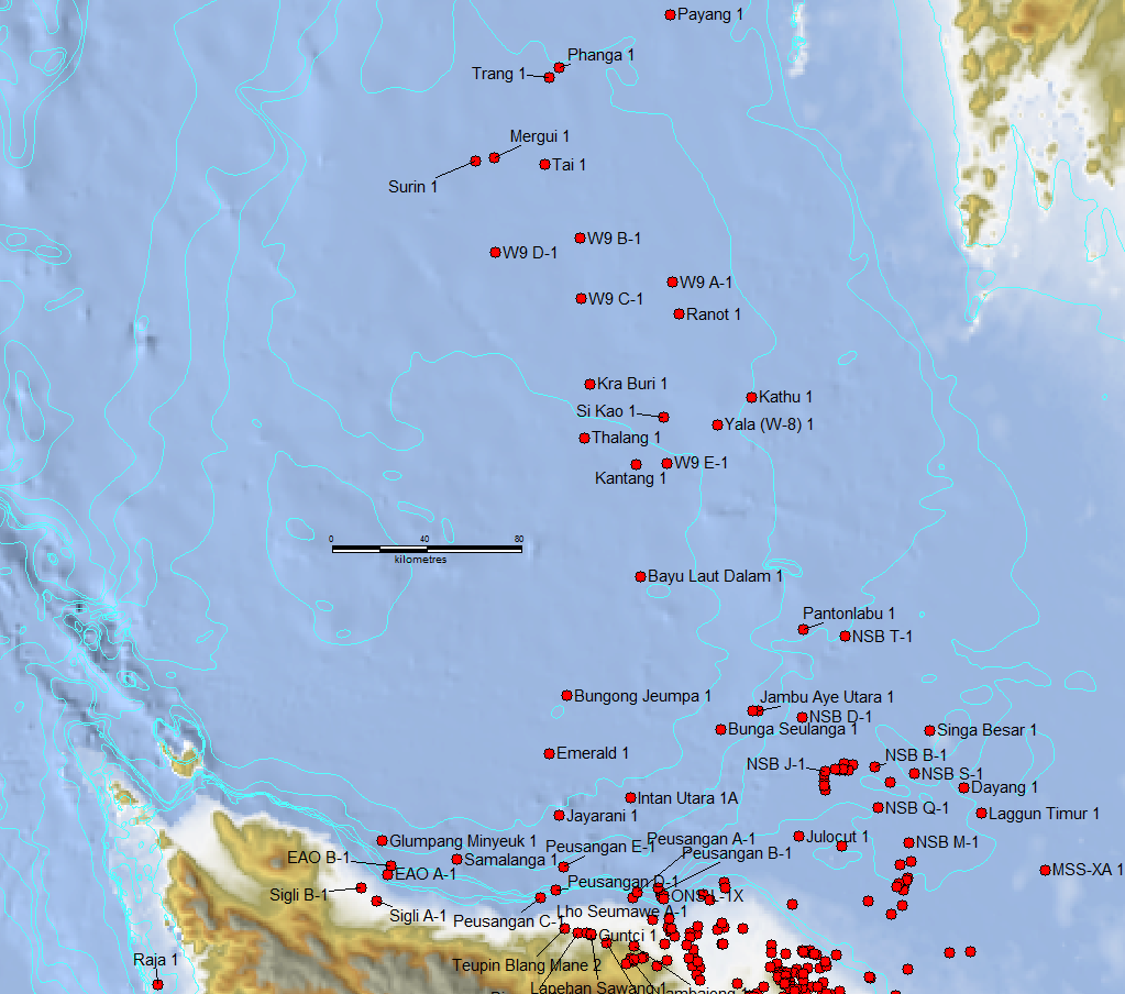
In North Sumatra / West Thailand Mobil and Esso exploration both noted mid-Oligocene abrupt change from thick fluvio-deltic siliciclastics to bathyal clays and occasional sands (Lunt 2019).

The data in the West Thailand wells is mostly on 1970’s wells drilled with extended open hole sections that were prone to caving of rich bathyal microfaunas into the drill cuttings. The similar aged Unocal wells did not note environment of facies with much detail but did include nannofossil analysis allowing better picking to the Oligo-Miocene boundary (several nannofossil extinctions, rather than relying on the evolutionary Globigerinoides datum)
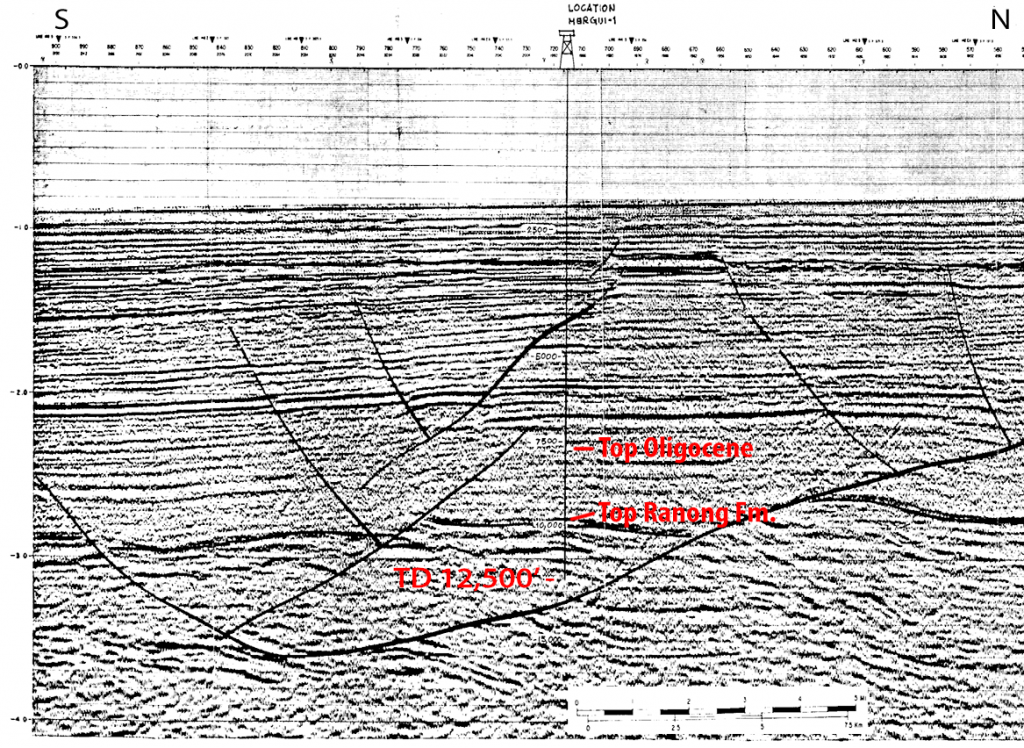
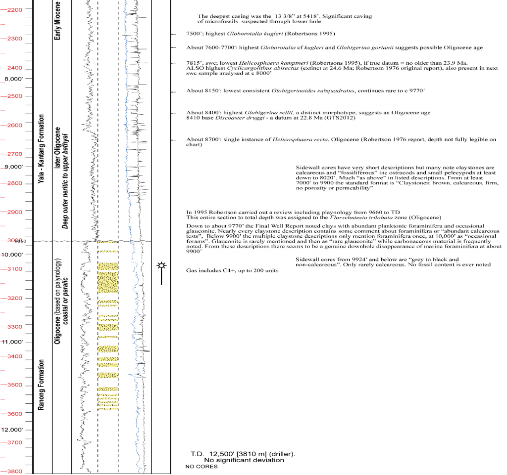
All wells tied to seismic suggest many hundreds of metres of delta-top Rangong Fm. (equivalent to the Agam or Bruksah Formation in North Sumatra) below several hundred metres of bathyal Yala Fm. (equivalent to the Pirak Formation of N Sumatra). The 1976 Mergui-1 well (Unocal) has the least seismically disturbed section as it drilled a very low relief anticline picked on the strong seismic reflection of top Ranong Fm. at c 9900 ft.


The log break at the top Ranong Formation is a single abrupt change on gamma and density/ resistivity logs, however the gentle folding of the structure means that about a hundred meters of Yala Fm. on the flanks is missing or highly condensed at the site of drilling. The Late Oligocene Yala Fm. is about 625 m thick. The Early Oligocene Ranong is at least 800m plus perhaps at least 200m undrilled by the well.
A simple calculation on sediments uncorrected for compaction give an approximate magnitudes of rates, with 34-28 Ma below the top Ranong Fm. being a kilometer thick (166 m/Ma) and the 28-24 Ma late Oligocene Yala Fm being 625m (156 m/Ma). The transition from Ranong to Yala, while a single log break might have taken a fraction of the 100m metres structural elevation or hiatus. If we assume half then a 50m vertical transition off structure would be about a third of a million years duration.
This is just an indicative calculation of scale. The transition could have occurred much faster, it is unlikely to have sufficient space to to have taken much slower. (The base Ranong Fm. might be lower as seismic indication of basement is poor, so the time scale would diluted by this effect. Un-compacting the sediments would add about 30% thickness and further increase the time scale -more m/Ma). So a large area between 50,000 and 100,000 sq. km. from North Sumatra and across western Thailand went from being a delta top setting lacking marine fossils to being a fully bathyal setting (estimated as >4000 feet / 1200m by Esso in wells such as W9 A-1, W9 B-1) within just one or two hundred thousand years. I doubt if the Gulf of Mexico palaeobathymetry scheme used by Esso to estimate water depth is directly transferable to SE Asia, but we are probably looking at >500m (middle bathyal) in a few hundred thousand years.
This equates to at least 15-20 m /Kyr, which is normally the high rate of sea-level change exclusively assigned to glacioeustatic causes (Miller et al. 2005), except that Miller et al were talking about global sea-level, but in the study area we are only concerned with regional relative sea-level (see this post). The magnitude of the N Sumatra / W Thailand change is greater as it continued for many hundreds of meters of vertical displacement, whereas the greatest glacio-eustatic event changed sea-level by only about 120 to 150 m (in the Pliocene through Holocene glacial ages).
Implications for exploration
Of course the outstanding question is, what was the palaeogeography in the Early Oligocene? West Thailand sediments are dominantly non-marine, North Sumatra clastics have occasional interbedded larger foraminiferal limestones. So where were the deep marine turbidites being fed by this sedimentation before the siliciclastic system retreated to its Late Oligocene setting? Were they the thick section (c. 500 m) drilled by the 1973 Raja-1 off the NW coast of Sumatra? (In which oil shows were recorded in sandy sidewall cores). This is a play either unrecognised or long forgotten. This is a part of the new world of exploration ideas being opened by the new tectono-stratigraphic framework.
References
Lunt, P., 2019. Partitioned transtensional Cenozoic stratigraphic development of North Sumatra. Marine and Petroleum Geology 106, 1-16
Miller, K.G., Kominz, M.A., Browning, J.V., Wright, J.D., Mountain, G.S., Katz, M.E., Sugarman, P.J., Cramer, B.S., Christie-Blick, N., Pekar, S.F., 2005. The Phanerozoic record of global sea-level change. Science 310, 1293-1298
Be First to Comment