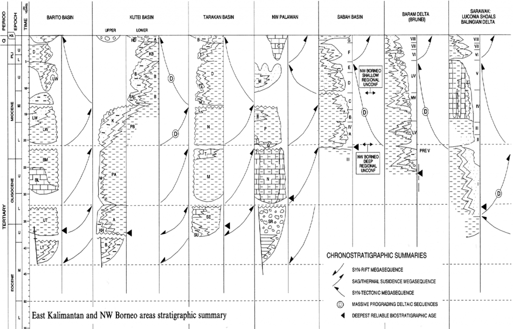
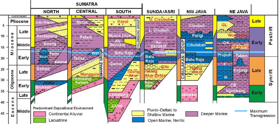
Below are two graphic summaries that are typical for introductory texts on SE Asian geology. Basins formed with a stage or two of rifting then a “sag/thermal subsidence” phase, followed in some basins by a compressional period. Most summaries like this suggest some correlation between rift and sag units across multiple basins. Most geological summaries like this were drawn by geologists with little training in stratigraphy, who were unable to challenge reported observations to either break or refine the implied approximate correlations. They also did not use geohistory analysis, so the differentiation of rift to sag was based on fault density/ fault movement on seismic, which is not the same thing. (Doust and Sumner, 2007, shown below, did plot very simple burial histories, but lacking the accommodation space of palaeobathymetry these were not full geohistories, and lost a lot of important detail as a result)


The colour-coded Doust and Noble summary suggests that most basins around Sundaland reached the end of Late Synrift (orange) close to the Oligo-Miocene boundary and then entered a Postrift stage. Again if geohistory, or just a bit more stratigraphic sense, had been used it would have been noted that nearly all basins saw an abrupt subsidence and transgression on the Oligo-Miocene boundary (e.g. Malay Basin to Sarawak, and the Java Sea – Makassar Straits region). In the central South China Sea and central Makassar Straits this was a time of massively accelerated rifting, reducing in magnitude laterally, but still a major sequence boundary over most of Sundaland, as entire basins and their sedimentary systems shifted. This was not a shift to a thermal sag phase, but one of many successive subsidence events that compounded to attenuate Sundaland. The mid-blue tie line on the Doust and Noble figure above is annotated as the maximum transgression, a feature noted by several authors (e.g. Longley 1997, Netherwood, 2000) as a eustatic event at roughly 15 Ma, near the end of the Early Miocene. It was not a eustatic maximum flood but the end of the Sundaland attenuation and subsidence phase.
Many of the new papers summarised in this blog deal with revisions to the stratigraphy of basins around Sundaland that contradict the over-simple cartoon summaries above. This is why in many posts I repeat the importance of evidence rather than expectation (model; or forced correlation), and the importance in assessing the reliability of the evidence. What this major, multi-paper, review of stratigraphy around Sundaland shows is that Yes, many of the unconformities in the figures above do correlate; but that there are more of them than assumed, and they wax and wane in magnitude according to geography and their tectonic causes. Secondly, in the zones of highest magnitude they are invariably described as break-up unconformities. Thirdly they describe a history of extension and subsidence (with some local compression between adjacent terranes moving at different rates) that began near the end of the Middle Eocene and continued for 20 to 25 Ma as Sundaland sank and was transgressed (while global sea-levels were falling). This extension had two axes of focus, in the South China Sea and the Makassar Straits. This subsidence of Sundaland terminated at slightly different times in different areas as the plates of Australia and the Philippines impinged on Sundaland.
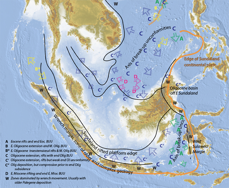
So this leaves us with a different tectonic model. Five, six, or locally seven rift phases with varying palaeogeographic expression, but each event correlating quite precisely in time between adjacent basins. The rifting began along the eastern margin of Sundaland, and both rifting and plate attenuation migrated westwards in stages. The South China Sea axis of extension was the largest and had several wrench faults offsetting different geological provinces. The Makassar Straits was linked to a transform wrench system in the south, and this passed across the area under the entire island of Java and outboard Sumatra (see draft map at the end of this post). The so-called back-arc basins are produced off the inboard side of this wrench system with mostly north-south basement faults and a history of transpressional strain
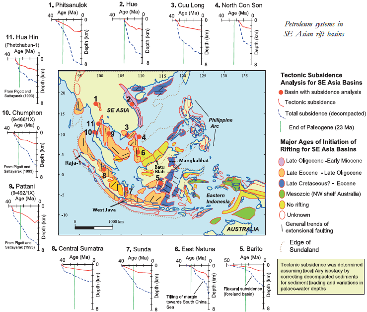
This unified tectono-stratigraphic framework will become a new classification of post middle Eocene South East Asian basins (without all the irrelevant “back-arc” terms). This is just the jargon that will explain a new and continuous palaeogeographic framework for the region. This will allow projecting into under-explored regions that are not even marked as “basins” on most oil company maps, yet often have thousands of metres of sediment and hydrocarbon seeps. A joining of pieces that was not possible under the old ideas, by the application of an evidence-based tectono-stratigraphic framework. A new map of this is in progress, but below is one of the better old summaries, from Doust and Sumner (2007) which recognises the blue areas are the slightly older basins on the eastern Sundaland margin. However there are numerous errors. The yellow areas of “No Rifting” in NW Borneo includes the enormous late Early Miocene Bunguran Trough rift (Lunt and Madon, 2017) and strong Oligocene rifting and attenuation under most of the offshore Sarawak area (Lunt, 2019). However, the Tarakan area of NE Borneo marked in Blue has no history of rifting.

The coming new framework (draft sketch map of basin relationships shown below) therefore removes the old terminology of synrift and sag. Geohistory analysis shows that thermal sag was never really a thing in Sundaland basins. Postrift did not actually mean much anyway, except perhaps less local faulting on seismic. It was all misapplied, weak jargon clouding our concepts and suggesting very slow, gradual tectonic movement, which is not really a typical feature of the region. We can now tie episodes of faulting in each basin to episodes of extensional sedimentation, within which sedimentary facies (the elements of petroleum systems) can be mapped out in a new and regional framework. We can present to investors a robust and cross-referenced suite of work that reassures in the risky and expensive business of exploration. If a loosey-goosey technical presentation accompanies a request for many millions of dollars, it had better mask itself under some highfalutin modern technology. This will disguise the fact the most companies working the same area have historically interpreted fundamental sequences and rift and sag units in quite different ways (compare Longley’s basins summaries with those of Doust and Noble; all workers with impeccable pedigrees). This is symptomatic that we were still stuggling to understand the basic geology.
Peter Woodroof and I recently made some overview summaries for these sedimentary episodes and their controls on carbonate deposition. New work is being prepared on the underlying tectonic mechanism, in light of new stratigraphic discoveries impacting plate tectonics. The Early Miocene transition from extension to compression is complex, but there is already much new work on the following compressional phase, from the Malay – Natuna Basins, Sarawak, Sabah and the southern margin of Sundaland. The end result will be a dynamic new geological framework for the region.

So to re-cap, the evidence points to multiple rapid, extensional phases as rifting migrated westwards and compounded in stages, as Sundaland attenuated and subsided between about 40 and 15 Ma. The most severe rifting and extension was in the South China Sea and the Makassar Straits, but there were numerous wrench faults with synchronous times of movement. In the absence of subduction of a Proto-South China Sea plate, the entire process was one of the stretching of Sundaland, but with stress culminating in episodic strain roughly half a dozen times. The speed of these processes currently points to lithospheric, probably crustal, processes that locally involved break-up unconformities.
References
Doust, H., Sumner, H.S., 2007. Petroleum systems in rift basins – a collective approach in Southeast Asian basins. Petroleum Geoscience 13, 127-144
Doust, H., Noble, R.A., 2008. Petroleum systems of Indonesia. Marine and Petroleum Geology 25, 103-129
Longley, I.M., 1997. The tectonostratigraphic evolution of SE Asia. In A. J. Fraser, S. J. Matthews, & R. W. Murphy, 311-339. Geological Society Special Publication No. 126.
Lunt, P., 2019. A new view of integrating stratigraphic and tectonic analysis in South China Sea and north Borneo basins. Journal of Asian Earth Sciences 177, 220-239 (doi.org/10.1016/j.jseaes.2019.03.009)
Lunt, P., Madon, M.B.H., 2017. A review of the Sarawak Cycles: History and modern application. Geological Society Malaysia Bulletin 63, 77-101
Lunt, P., Woodroof, P., 2021. Tectono-stratigraphic controls on Cenozoic SE Asian carbonates. SEPM Special publication, Cenozoic Isolated Carbonate Platforms – Focus Southeast Asia, doi.org/10.2110/sepmsp.114.06
Netherwood, R., 2000. The Petroleum Geology of Indonesia. In Overview of Indonesia’s Oil and Gas Industry, 174-227. Jakarta: Schlumberger.
Peter, Nice overview. I was puzzled by the no rifting in northern Borneo, so glad you have tackled that one. People like simple models, which is why statements like, ‘rifting progressed from east to west’ have a lot of adherents. I think the over-riding theme of your essay is that in areas of the globe with high levels of tectonism, local effects trump global or regional effects, so unfortunately we have to deal with SE Asia with higher granularity than other areas people may be more familiar with. Looking forward to seeing the ‘evolution’ of your basin classification figure above.
Thanks for the comments Misha,
People like simple models, but I have found it very hard to come up with a new model, and then reduce it to a simple, easily envisaged form that tallies fairly with the ambiguous data.
I am proceeding slowly on the basin classification. I can seen a distinct tectono-stratigraphic pattern but we just dont know the mechanism. Structural geology is the link, so I need to get the stratigraphic story sorted out, and then present this to someone like Sharam at Petronas for qualified consideration on this topic.